NWT
PINE LAKE BEACH
The waters around NWT are usually chilly, but not at Pine Lake Beach. Within Wood Buffalo National Park, about an hour outside of Fort Smith, residents can plunge into waters that are warmed by the rivers flowing in from the south.
“It gives you that feeling of getting away from everything because you have this wilderness setting,” says Fort Smith Economic Development Officer, Diane Seals. “It’s just a place to cool off. It’s very accessible and it’s a beautiful spot.”
In July, park staff organize an event that brings hundreds of visitors out for activities like a canoe race, a three-legged race, and a BBQ picnic. And the aquamarine waters make for beautiful photos.
POINT LAKE BEACH
Hop in a Twin Otter and fly about 200 air miles due north of Yellowknife and you’ll come to Point Lake, an oblong waterbody huddled in the NWT, but not far from the Nunavut border. On the cusp of the Arctic Circle, it’s one of the largest lakes fed by the Coppermine River. And on its southwest end, surrounded by sand and taiga, is Peterson’s Point Lake Lodge.
This well-known wilderness retreat boasts incredible trout fishing and opportunities to view aurora. Yet one of its most prominent features is the sandy beach that welcomes guests when they first touch down. For first-time visitors, it can be a bit of a shock to see a beach in the Arctic, says lodge owner Amanda Peterson.
“I probably, in a way, take it for granted, because it’s commonplace for me—but not for others,” she says. “It’s not something they typically think about.”
The lake owes its sandy shores to an esker, the sedimentary evidence of meltwater deposits from glacial retreats thousands of years ago. Nowadays, it serves mostly as a boat launch and a parking area for bush planes delivering supplies and guests to the lodge. But when the midnight sun heats the barrenlands in the height of summer, it can be a pretty great place to soak it all in.
“Last year, we had these three glorious days,” Peterson remembers. “We took these lounge chairs down [to the beach] and we warmed up enough for us to go in and enjoy a crisp and fresh dip.”
It wasn’t a long swim, Peterson quickly clarifies, since the water was still pretty cold. Still, guests can always jump into the wood-fired sauna afterwards to warm up.

WHITEBEACH POINT
With swathes of soft, white sand stretched out along the shore, Whitebeach Point is aptly named. Roughly 50 kilometres west of Yellowknife on the North Arm of Great Slave Lake, the water here is astonishingly cool and clear. Ignore the spruce trees and the fact this spot backs onto a large bison sanctuary, and you could convince yourself that it’s the tropics.
The Tłı̨chǫ have always used the area to camp, hunt and fish, and today, the Tłı̨chǫ Government keeps those traditions alive by hosting community gatherings here. In recent years, people have traveled to Whitebeach Point midsummer via chartered floatplanes and motorboats to go duck hunting, berry-picking, swimming, and play the odd game of horseshoes.

NAIJU RIVER
There are few places more revered in the world of trophy fishing than Great Bear Lake. Every year, anglers from around the globe flock to the massive lake, lured by the prospect of catching monster 50-pound trout.
That’s why Ontarian Harold Ball has gone there every summer for the past 40 years, anyways. “It’s the [fourth-] largest freshwater lake in Canada—so it’s bigger than Lake Ontario, bigger than Lake Erie,” he says. “And other than Délı̨nę, a community on the southwest corner, it’s virtually uninhabited. It’s just incredible.”
Over four decades, Ball has become familiar with the lake’s sandy nooks and crannies. Caribou Beach to the east is notorious for bulldog flies. The Sand Flats to the north have shallow, clear waters. Ford Bay is home to Plummer’s Trophy Lodge on the Smith Arm, and it’s where guests kick back with a beer after a long day of fishing.
Yet Ball’s favourite place has got to be the Naiju River. A two-hour motorboat ride from the lodge, it’s rarely visited. The esker-like landscape is dappled with patches of white sand. A small white crib with a cross marks the grave of a Dene medicine man named Kargegie, maintained throughout the decades by people from Délı̨nę who occasionally travel there by boat. It’s a great spot to stop for a shore lunch, to cast a line, and to pay respect to the history of the land and its people, all while enjoying the incredible peacefulness surrounding you.
“It’s just kind of you, your fishing partner and your guide,” Ball says. “The only thing you hear is the wind from time to time.
“It’s a little bit of heaven on Earth, quite frankly.”

YUKON
KATHLEEN LAKE BEACH
The turquoise water is smooth like glass, ruffled only by the occasional breeze. Rocky sand crunches softly underfoot. In the distance, white-capped mountains reach into the sky, among them the 1,990-metre colossus that is King’s Throne. The view is majestic
and pristine.
Known as Mät’àtäna Mǟn, or “Something Frozen Inside Lake” in Southern Tutchone, Kathleen Lake is idyllic. Nestled within Kluane National Park and Reserve, it serves as one of the most popular stops in the 22,013 square-kilometre park.
There’s plenty for visitors to enjoy. You can launch a canoe and go for a paddle, or stroll down the interpretative boardwalk that highlights the park’s natural and cultural heritage. More adventurous folks hit the hiking trails that lead to the King’s Throne Peak, then finish off the day with a quick swim in the lake’s cool waters.
But truthfully, the best way to experience this beach might just be sitting back on the shore and taking in the breathtaking scenery.
“When we have friends and family visiting from away, this is one of the first places we would take them,” says Carly Sims, Kluane’s visitor experience manager. Not a bad spot to have in your back pocket when you want to brag about the wonders of
your backyard.
What’s more, it’s a wonderful place for the community to gather. Staff host Music in the Park events every summer, performing educational ditties about the park. In the fall, the Northern Nights Festival sets up on the beach, celebrating the return of the night sky with art workshops and traditional storytelling.
As Sims says, “It’s just a place with a lot of opportunity.”

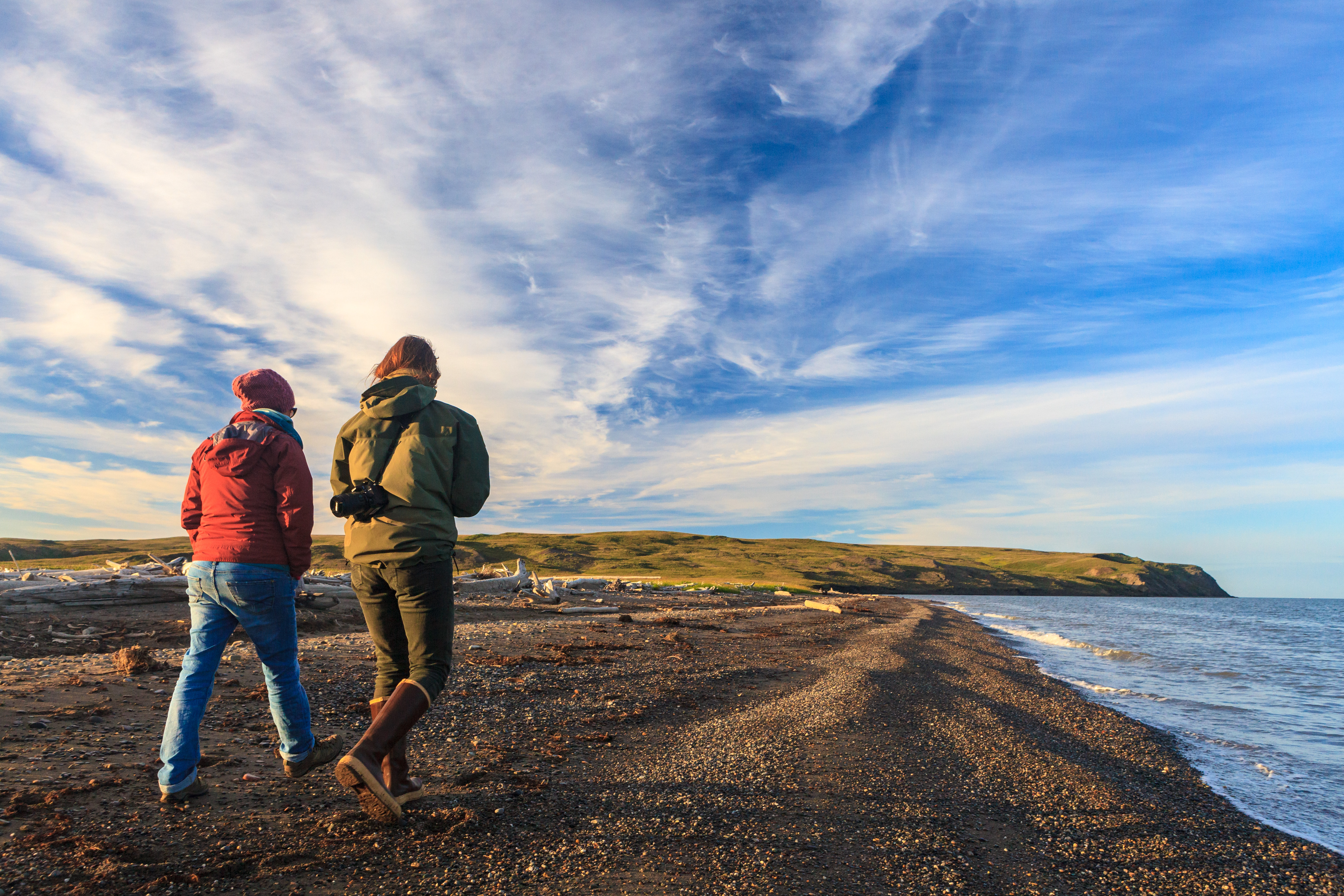
HERSCHEL ISLAND
Just five kilometres above mainland Yukon, Herschel Island is a lone patch of land inhabiting the Beaufort Sea. Inuvialuit have traveled here to hunt caribou and bowhead whales since time immemorial, and the spot has hosted a litany of other visitors throughout the centuries: American whalers, offshore oil companies, traders, missionaries, Northwest Mounted Police. Nowadays, the entirety of its 116 square-kilometres serve as Qikiqtaruk Territorial Park—co-managed by the Inuvialuit and Yukon Parks—and welcomes only a handful of lucky guests every year.
Though best known for its historical relics and abundant wildlife (namely the large colony of Black Guillemots and occasional Porcupine caribou), Herschel Island is also wrapped in a delightful pebble beach littered with driftwood. It’s a great spot to walk and appreciate the wonders of the island alongside the vastness of the Beaufort Sea.
NUNAVUT
FURY BEACH
Tucked away on the east coast of Somerset Island, Fury Beach is anything but easily accessible. In fact, EYOS Expeditions’ regular Arctic cruise through the Northwest Passage is only able to safely land there about 30 percent of the time.
“It’s not uncommon that it’s covered with ice, or wind blowing from the north or east makes it just about impossible to land,” guide Ken Burton says. “It’s a really confined area.”
So, maybe not the best place for a day of swimming. “But if we can get there,” Burton continues, “it’s got a really good story.”
The story Burton is referring to is that of the HMS Fury, a British bomb ketch which was ensnared in ice floes during a voyage in 1825 and abandoned by its crew. While it may sound similar to other ill-fated journeys (we’re looking at you, Franklin), the Fury is actually something of a success story. It saved the life of Scottish naval officer John Ross, who found Fury’s abandoned caches of supplies four years later. Ross and his crew were traveling overland following their own ship’s wreck in the Gulf of Boothia. They survived off the Fury’s stores one winter, then used the ship’s old rescue boats to sail up to Lancaster Sound. There, they were spotted and rescued by a whaling vessel that brought them back to England in 1833.
Evidence of Fury’s wreckage has long since washed away, but the drama of its abandonment remains and makes for a fantastic stop during cruise expeditions, says Burton. “These are really experiential tours. When we go ashore to beaches like that and I’m doing a history talk, I can say, ‘It was right here. This is where the Fury was, and this is what happened.”
The scenery around the beach isn’t half bad, either.
“It’s quite colourful and spectacular at the right time of year,” says Burton. “The flora is beautiful. Up behind [the beach are] rolling hills with beautiful hiking, and you see lots of animals around. It’s a good spot.”
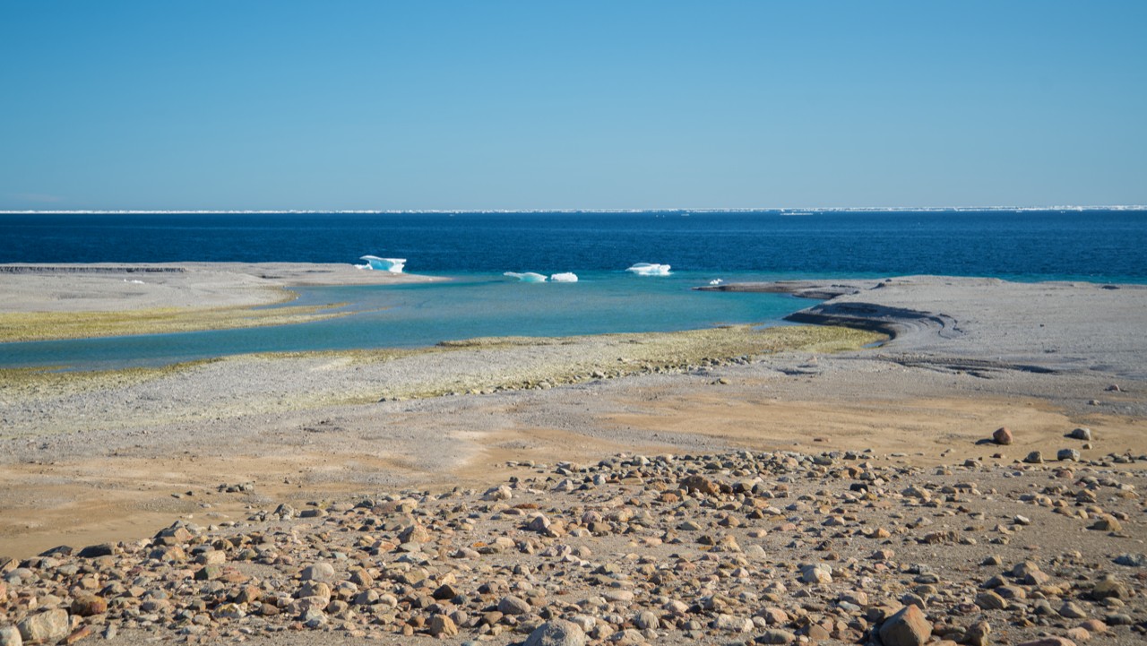
LONG POINT
It’s got to be pretty hot before residents of Cambridge Bay will consider going into the Arctic Ocean. Seawater around this hamlet on southeastern Victoria Island hovers at a cool -1.8 degrees Celsius year-round. Yet as summer temperatures continue to steadily turn warmer (with highs between 20 and 25 degrees Celsius in the past few years—previously unfathomable), more community members are braving the chilly dip just to cool down.
Good thing they’ve got the perfect spot to go. About a half hour drive out of town is Long Point, a sandy expanse along the western entrance of the Northwest Passage where families launch kayaks and motorboats, build sand castles, and yes, even go for the odd (short) swim.
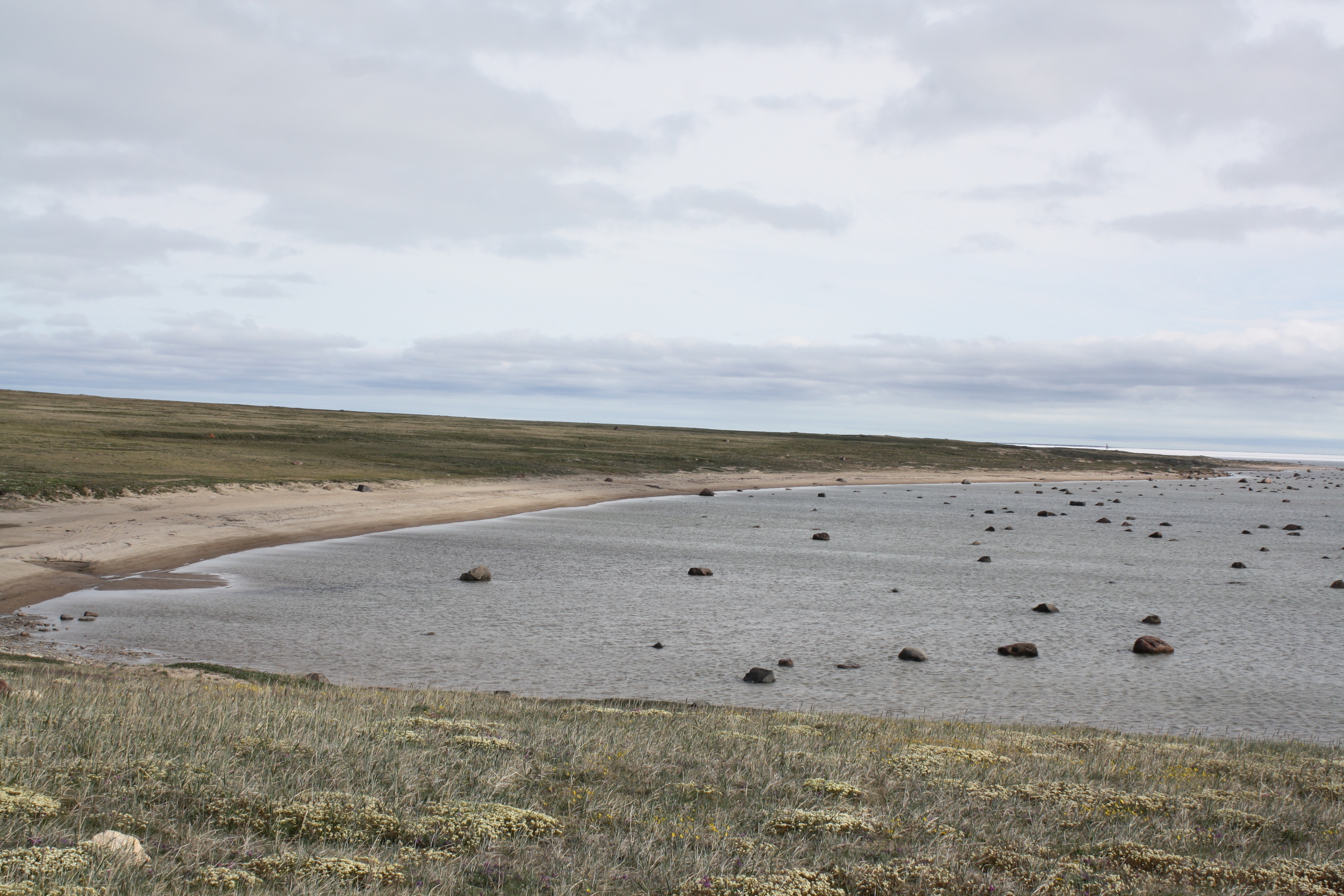
APEX BEACH
In the 15 years he has lived in Iqaluit, Frank Reardon has yet to find a place around the city he loves more than Apex Beach.
Here, the ocean laps the long shoreline of Iqaluit’s nearby satellite community. Above the beach, several former Hudson’s Bay Company buildings stand the test of time, while on the beach itself sits an Apex signature—a permanently grounded and abandoned red fibreglass barge—known around town simply as “the red boat.”
Reardon and his family have spent countless weekends there. When his two kids were little, they were particularly fond of low tide and would spend hours hunting for little critters left lying on the sand after the water spit them out—everything from sea lice to small Arctic char.
Now that they’re older, Reardon and his daughter love to explore the area in their kayaks. And they are far from the only ones who enjoy the beach. “On a nice evening, you see lots of people down there having little fires or picnics,” Reardon says. “It’s always very lively.”
One year, several large chunks of glacial ice drifted into the harbour. “You would go down, chip pieces off, then melt it and drink it. It was really good, this thousand-year-old ice.”
Reardon is a photographer in his downtime, and you couldn’t ask for a more scenic landscape to capture. “It’s very neat taking photographs when the ice is starting to cover some of the glacial erratic rocks scattered around the tidal flats,” he explains. “In August and September, the sunsets are incredible.”
“And of course, the red boat always gives a nice depth of field.”

How are beaches formed?
Say the word “beach,” and the first thoughts that come to mind are relaxation, fun, and an escape from the stresses of everyday life. But make no mistake—for Mother Nature, beaches are a labour of love thousands of years in the making, combining just the right amount of geology, weather, and of course, patience.
According to sedimentologist Rob Rainbird with the Geological Survey of Canada, a beach needs three key ingredients to form: standing water (an ocean or a lake will do), wind (to get some wave action going), and a source of sand, which is often the bedrock. Wind stirs up waves, which carry and then deposit the sediment that has been mixed up in the water onto the shore and voilà. You’ve got yourself a beach.
Sand up here is most often composed of quartz. “Quartz is a very resistant mineral, so it can withstand a lot of erosion and reworking,” says Rainbird. “And most of the beaches in the North would be quartz-rich because they’re being derived ultimately from the Canadian Shield.”
But this is all pretty standard, run-of-the-mill beach stuff. If you want something a little snazzier and specific to the North, Rainbird says, look to “raised beaches” instead.
These sandy expanses stretch in waves across the landscape. To understand them, we have to travel back more than 10,000 years, when glaciers—particularly the massive Laurentide Ice Sheet—covered most of North America.
The ice’s immense weight “depressed the land where it was thickest,” explains surficial geologist Isabelle McMartin, pushing the Earth’s crust down. When the ice sheet melted, oceans then flooded the lowlands and formed beaches in their typical way. Yet ever since, the land has been slowly rebounding, rising back up without that ice to push it down. Around Hudson’s Bay, it’s currently rising about one centimetre a year.
It’s a careful balance. The land rises up; the sea level goes down. And suddenly, the beaches that had formed are no longer next to the water. Instead, they are patches of sediment sitting inland, sometimes 100 kilometres from the current shoreline. Some of the most prominent examples of this phenomenon can be found around Baker Lake, Nunavut.
“It’s fairly recent, too,” says McMartin. “The last glacial maximum was about 20,000 years ago, and you need [it all] to melt. So, it’s as if you were melting the entire Antarctic ice sheet in 20,000 years. In geological time, that’s not that long.”