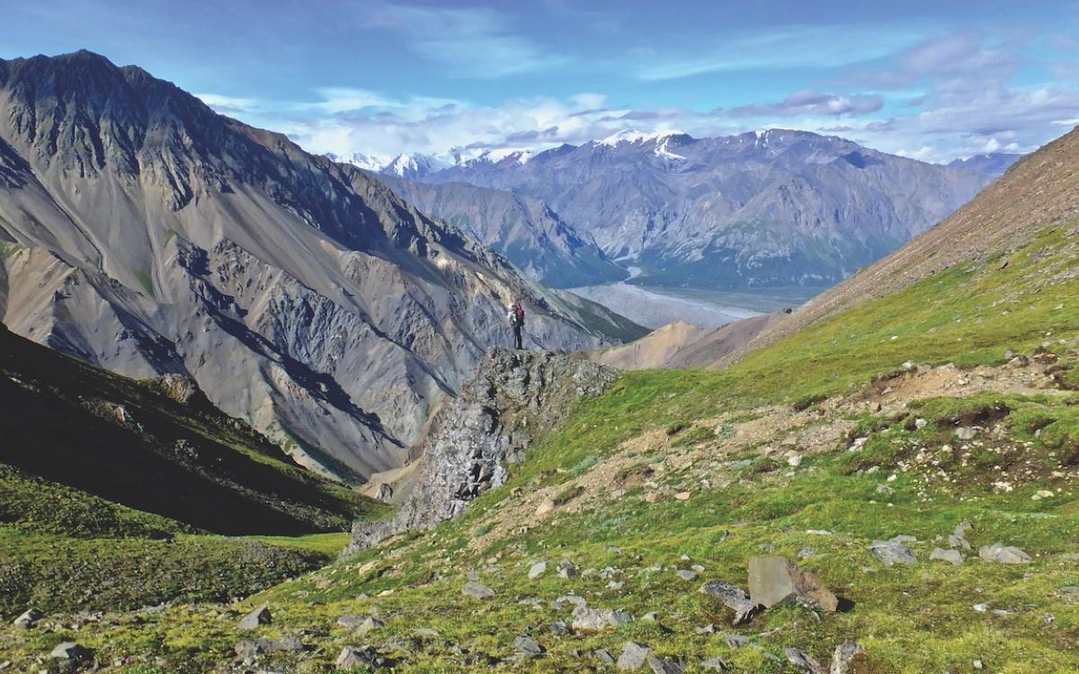
We have no idea where to descend from this alpine ridge. Cliffs and terrifyingly steep scree slopes all look impassable. To ease our uncertainty, we look for signs of others having gone before, perhaps a bootprint, but none appear. Trails here belong to Dall's sheep and the paths don’t go where we want or can.
Armed only with topographical maps and a vague Parks Canada route description, my partner John and I are not lost but apprehensive. Parks Canada’s description is of little use. “Once up on the ridges continue southwest, staying to the west on the ridges, as far as possible. Drop down a scree slope to the left. Once in the grass gully, follow it down veering to the left. Don’t take the first gully down but stay left until you come to a very steep canyon. Here you will find a scree slope you can hike down...”
But everything below us is ridges and gullies and scree slopes. Which one are they talking about? Reading on doesn’t ease our worries. “There are several gullies... They are all tricky and steep with a lot of loose scree and rocks. Choose your route carefully because some gullies are dangerous and impassable.”
Standing here on Hoge Pass with no discernible way down, fear begins tingling our bellies.
When picking up backcountry permits, Parks Canada visitor centre staff foretold this would happen to us on Hoge Pass, just three days into our seven-day backpack. It happens to nearly everyone who decides to tackle Kluane National Park’s classic 110-kilometre Dän Zhùr, or Donjek, backcountry route.
Instead of becoming overwhelmed with uncertainty we shrug off our packs, and our worries. Sure, we need to find a safe route down, but for now we want to sit in this electric green alpine setting. Dall's sheep are grazing the slopes above. The sky is an unadulterated blue. Arctic ground squirrels and picas are scurrying about nibbling wildflowers. A golden eagle soars the thermals. In the distance, the glaciers of the Icefield Ranges glint in the noon day sun. It is an idyllic Yukon summer day. We’ll resume the route-finding in a little while, but for now there is simply too much wilderness to worship.
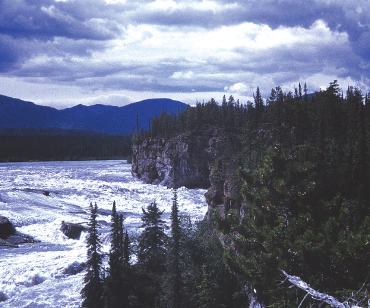
What makes the Donjek so challenging, so alluring, is that it is a route, not a trail. There is no maintained path to follow, no cairns to guide us across the tundra, mountain passes and forest. The few yearly hikers don’t leave much of a trail. We are on our own, deciding where to go. Adding to the stress of route-finding are all the big and potentially scary wildlife one must always be vigilant for: wolves and grizzlies, moose and wolverine. Mix in unpredictable weather and glacier-fed creeks that frequently flood and you’ve got all the components for an epic adventure.
How epic seems to vary. For the experienced wilderness tripper— comfortable with route-finding and hiking rugged terrain, those who know how to keep pack weight down and what foods to take—the Donjek is tough but fun. For the inexperienced and GPS-dependent backpacker it can be a humbling awakening.
Some struggle with sore feet long after they have finished or a hunger that took days afterward to satiate. Many more complain the passes are too harrowing, the route-finding too difficult, the Parks Canada description inadequate. In conversations and online comments, some even say traversing the Donjek comes with feelings of “impending death.”
Perhaps this is why it is now common to download the GPS tracks of someone else’s trip off the internet before attempting the route. Doing so alleviates much of the uncertainty and stress of route-finding. The trouble is, the forerunners may not have chosen the path of least resistance. Conditions in the backcountry change daily. Decisions have to be made along the way—decisions a GPS cannot make.
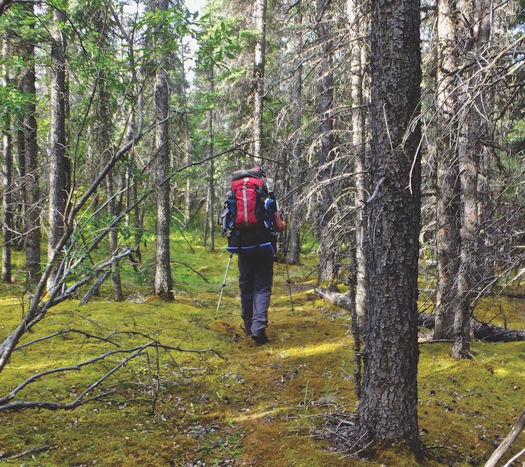
A young couple I met along the Donjek was misled more than once by their internet route. One day, it led them on a long, forested detour over a mountain spur—the high-water route used when the creeks are flooding but unnecessary on that dry day. Bushwhacking is soul-crushing, and creek beds are the preferred travel route when water levels allow. The couple spent miserable hours bushwhacking while we sauntered along sun-baked clay cliffs above the Donjek River.
Another day, they discovered their intended campsite, suggested by GPS, was six feet under a new beaver pond. With their electronics not indicating any other nearby sites, they were distressed, and unsure where to spend the night. Ironically, at that moment they were standing in an idyllic campsite of pepper scented dryas in a flat meadow, beside a clear-flowing stream.
The sad truth is people get lost in Kluane. People die. A solo backpacker went missing in the summer of 2011, but because he did not register his trip with Parks Canada or tell anyone his plans, his family did not know where he was. It was not until the fall of 2013 that backpackers near Hoge Pass found his backpack. His body could not be recovered until the following spring. What exactly happened to him is unknown.
Kluane is wild, vast and demands respect. It is not a place for egos. Parks Canada’s many warnings should not casually be ignored.
If the Donjek is too adventurous, the well-maintained Ä’äy Chù or Slims River trail is a worthy alternative. The three-day backpack to the Kaskawulsh Glacier rivals the beauty of the Donjek Glacier and the peak of Observation Mountain offers unparalleled views over the world’s largest non-polar ice field.
Traveling the Donjek with a guide can alleviate much of the toil and strain—the heavy packs, the navigation, the meal planning and preparation—while teaching useful backcountry skills. Hiking with a guide also means less time tormented by those feelings of imminent death, and more time drinking in all the wild the Donjek has to offer.
As John and I sit on Hoge Pass discussing our options, consulting our topo maps and surveying the slopes below, we settle on a gully to descend. A scree slope with solid rocky ledges to rest upon will take us most of the way down. While we can’t see our entire route down, a willow thicket near the bottom gives us hope. If willows can take hold, there should be footing firm enough for us.
Looking back on our route down Hoge Pass, we are fairly certain it was not the path Parks Canada suggested. But so it goes out on the land. In the seven days we traversed the Donjek route, we crossed flooded creeks, bushwhacked, met a grizzly, a wolf, more Dall's sheep, and a few mountain goats. We went the wrong way, found our way and had some good old-fashioned backcountry fun.
I can appreciate wanting to follow a GPS route. It would be less time-consuming than pouring over maps and discussing options. It would answer all of our questions.
But it would also erode the sense of adventure. With Hoge Pass behind us, there was relief that day. But soon again we were wondering, “Where now?”