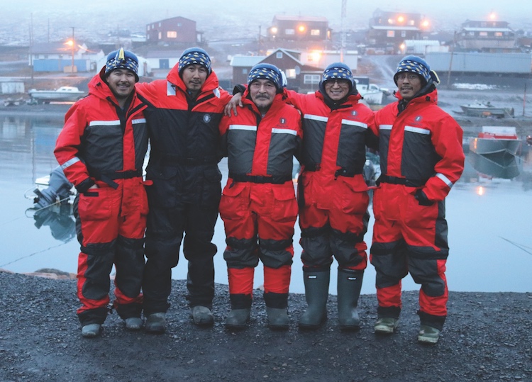
Ice is just starting to form on Resolute Bay in early October. Snowmachines were fired up two weeks back, and once it really gets going, “we’ll be walking down the street in snorkels,” Philip Manik laughs. Soon enough the snow will fall thick, a crust will form, and the water will freeze over completely, he says. They’ll head out on the ice in a month or so.
Manik is the chairperson of the local hunters and trappers organization. He travels far and wide to hunt, but he's never been to the new marine protected area around the northern tip of Ellesmere Island. “That’s 800 miles away,” he says. “I thought you were talking about Tallurutiup Imanga.”
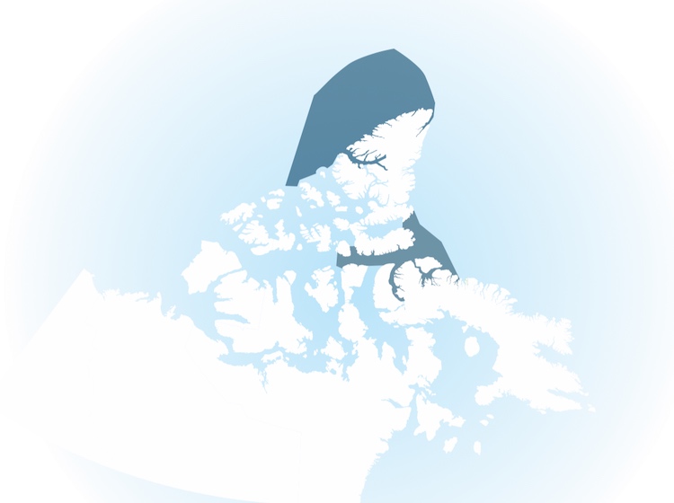
That marine conservation area along Lancaster Sound is a part of a bigger story. It’s 108,000 square kilometres of water, rich with marine mammals and critical to their migration. Three communities line the shore of Tallurutiup Imanga and two more are just outside its boundaries. These waters sustain them. In the winter months, Inuit hunt on the ice, in the leads of open water, says Manik. They hunt seal, polar bear, walrus, beluga, and narwhal, travelling on the ice between Somerset, Griffith, and Prince of Wales Island.
But I was asking about Tuvaijuittuq.
Encircling northern Ellesmere Island in Nunavut’s High Arctic, it’s made up of 320,000 square kilometres extending from Ellesmere’s shoreline, 200 nautical miles to Canada’s maritime boundary. And it’s mostly ice. The length of Ellesmere Island divides Tuvaijuittuq and Tallurutiup Imanga. As the tenth largest island in the world, that’s no small feat. But they’re a part of one system. Everything is a part of one system.
Interim federal protections prevent any new activity in Tuvaijuittuq for five years. With no permanent settlements, and only readily accessible by plane, there is very little human activity in the area right now. And perhaps the distance is a good thing. Manik says he’d hate to see a flood of people wanting to see the newest protected area, if they could get there. Over the five years of interim protection, the Qikiqtani Inuit Association, representing the people of this region, will go back to the communities to hear concerns like Manik’s and define what longer-term protection means.
“We’re keeping an eye on what’s happening up there,” Manik says. “This climate change is affecting everybody and everything. Especially up here.”
There is, perhaps, no better place to see the effect of climate change than Tuvaijuittuq—‘the place where the ice never melts’ in Inuktitut. If anyone were there to see it.
Sandra Inutiq, a chief negotiator with the QIA meets with me in her Iqaluit office in October. It’s been two months since an impact benefits agreement for Tallurutiup Imanga was signed and since interim protection was announced for Tuvaijuittuq. And there is so much more to do. Although the two marine areas are separate in geography and levels of human activity, they are inexorably linked ecologically. Preserving a way of life in Tallurutiup Imanga nods to what could be at stake in Tuvaijuittuq.
“How do you take measures to protect what’s predicted to be the last piece of ice?” asks Inutiq. “That’s the climate change issue.”
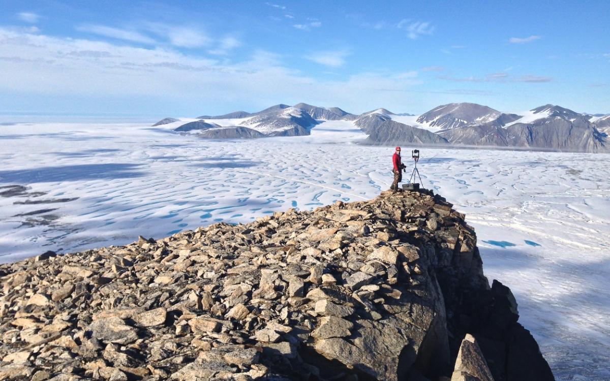
For 3,000 years the northwestern shore of Ellesmere Island was wrapped in a continuous ice shelf. It was the largest in the Arctic, even when Russia still had some ice shelves in play (they haven’t for about five years). From the accounts of early Arctic explorers, the Ellesmere shelf was estimated at around 9,000 square kilometres. That’s about half of Lake Ontario, and quickly thawing to its watery state.
Since the 1950s, various breakups have left seven individual shelves, three of which disappeared completely in the last two decades. “What we’ve seen is quite an acceleration since 2005,” says Ottawa-based glaciologist Adrienne White. “It’s unprecedented.”
When White published her thesis on Ellesmere’s ice cover in 2015, the remaining shelves collectively made up only 437 square kilometres (about the size of Kingston, Ontario, on the great lake’s shore).
“Between 1999 and 2015, there was a 42.4 per cent loss in the area,” she says. “And the complete loss of two ice shelves during open water events and record warm summers. These shelves broke off and drifted away.”
The Milne, one of three remaining ice shelves, continues to shrink every year, as does the Petersen, now disconnected from the glaciers that fed it. The Ward Hunt is the largest of the ice shelves that remain, but it too fractured over the past decade, leaving two distinct sections. In 2008, two ice islands calved off of Ward Hunt. The smaller was about the length of Central Park and twice its width. The larger was nearly twice that length.
The recipe for these breakups is record warm summer air temperatures, open water conditions and offshore winds, says White.
Normally, strong, multi-year sea ice acts as a buttress for ice shelves against battering waves. Without that buffer, and without being replenished by glaciers or sea ice that forms and adds to their mass, the ice shelves can only calve, break up and recede.
White first visited the Petersen on Ellesmere Island in the spring of 2010. She maneuvered a snowmachine up the ridges and down the troughs that characterize the surface of an ice shelf. On her final visit, in 2016, those smooth undulations were replaced by sea ice and open water.
“This is the most northern land in Canada and it’s one of the most directly impacted by climate change,” White says. “One year I’m Skidooing across the Petersen Ice Shelf and then that ice I was Skidooing on isn’t there. It’s a dramatic, dramatic change.”
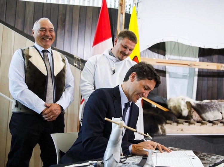
On August 1, Prime Minister Justin Trudeau flew to Iqaluit. Flanked by federal and territorial dignitaries, as well as Qikiqtani Inuit Association President P.J. Akeeagok, Trudeau announced the signing of the Inuit Impact Benefit Agreement for Tallurutiup Imanga. As its chief negotiator, Inutiq was ecstatic; this agreement, this conservation effort, was a long time coming. It was an example of the Nunavut Land Claims Agreement realized.
Amongst all of the excitement, Trudeau made a second announcement—the creation of Tuvaijuittuq. It, too, was the culmination of decades of work by Inuit and environmental groups, who've long pushed for useful protection of the Arctic archipelago.
Going back to the late 1960s, the Canadian government started allowing permits for oil and gas exploration in Arctic waters. Inutiq says that’s when Inuit saw the need to protect Tallurutiup Imanga and other areas like it. “This was the impetus for trying to get a land claim agreement signed, to protect our way of life, to protect the wildlife and their habitat.”
For the World Wildlife Fund of Canada, Tuvaijuittuq—or the ‘Last Ice Area,’ as they call it—came into focus a decade ago when the environmental NGO was in Washington, D.C. discussing record low sea ice and subsequent habitat loss, says Paul Crowley, vice-president of Arctic programs for WWF-Canada. With climate models in hand that projected northern Nunavut and Greenland as the last ice areas of the Arctic, the NGO recognized these areas will be critical habitat for ice-dependent species like polar bears when all others are gone: a bomb shelter in a climate emergency.
“We know the Arctic basin is very important for ice persistence, but also because of the continental shelf drop-off and oceanography there,” says Crowley. Through a project on marine ecology conservation, WWF-Canada located a concentration of gullies and canyons in the High Arctic Basin—the exact kind of environment in non-ice-covered waters that provides critical habitat to various species including corals, marine mammals and fish. For Tuvaijuittuq, Crowley says, protecting the area is not only important to preserve sea ice, but may also prove important should that summer sea ice disappear.
And here, environmental change has a clear domino effect. Behind Ellesmere’s ice shelves, bodies of water called epishelf lakes form, dammed by the shelf itself, explains White. Surrounded by ice, they are freshwater lakes sitting on top of the Arctic Ocean. “You end up with this unique ecosystem of freshwater creatures,” she says. “But unfortunately, when the ice shelf breaks, you lose the dam. The lake floods out and you lose all of this.”
Flash forward to the summer of 2018. The QIA submitted a prospectus document to the federal government. This was the pitch for the Inuit Impact Benefit Agreement for Tallurutiup Imanga. It had a much broader scope than direct employment and some funding dollars. As people who live off the land, the agreement was built around securing food sovereignty by way of conservation. Inutiq likens it to the work of Ducks Unlimited; protecting wetlands so duck populations remain healthy, and people can continue to hunt them.
“In the Inuit worldview, your relationship to your environment is the epicentre,” says Inutiq. “That means a relationship of reciprocity: the land provides and you take care of the land and that’s the relationship that you want to maintain.”
While the QIA awaited a response to their pitch, it received a letter from the Department of Fisheries and Oceans, outlining the federal government’s interest in creating a marine protected area in the High Arctic Basin.
Two years earlier, Prime Minister Justin Trudeau and then-President of the United States Barack Obama had released a joint statement on Arctic conservation. It included a five-year moratorium on oil and gas development, an agreement to keep unregulated fisheries out of the international maritime boundaries crisscrossing the central Arctic, and a promise towards 10 per cent protection of Arctic marine areas by 2020 (which the addition of Tuvaijuittuq this year surpasses).
But the marine protected area DFO initially put forward fell outside the Nunavut Settlement Area, says Inutiq. Still wondering whether the government would respond favourably to its benefits agreement proposal for Tallurutiup Imanga, QIA suddenly had a new strategy.
“What we said is, ‘Why don’t you include areas within the Nunavut Settlement Area and we will support the process for creating what we called Tuvaijuittuq’” says Inutiq. “‘We will support that if you support Tallurutiup Imanga.’” That’s when negotiations started to move.
Throughout the eastern Arctic, the QIA has a list of areas it’s interested in protecting. It includes Pikialasorsuaq (the North Water Polynya), areas around Sanikiluaq and Igloolik, and another near Pangnirtung where belugas calve. The High Arctic Basin was certainly on that list, but in some ways Tuvaijuittuq jumped the queue.
“You just never know what larger political events will unfold, so you just have to think on your feet as negotiations progress,” says Inutiq. And that Arctic leap-frogging is what helped the groundbreaking Tallurutiup Imanga benefits agreement to be signed—creating a paradigm of protection for Tuvaijuittuq, Tallurutiup Imanga, and future endangered waters.
“We would have gotten there eventually,” says Inutiq. “I think we were focused on trying to set a precedent for a conservation economy model for Tallurutiup Imanga where Inuit take on a larger role for managing conservation.”
Over the next five years, through community consultation, Inutiq says they’ll figure out what conservation looks like in Tuvaijuittuq. They’ll determine if the boundaries should remain as proposed, and what activities would be permissible within them. If the boundaries remain as is, the benefits agreement for Tallurutiup Imanga will apply for Tuvaijuittuq as well. That agreement included federal funding for small craft harbours and food processing facilities for the nearby communities. There will be funding for guardians—called Nauttiqsuqtiit in Inuktitut—who will work as stewards, search and rescue officials, and hunters and providers for their communities. Already, 31 positions have been created for Tallurutiup Imanga, says Inutiq. And there is a focus on research and monitoring that includes Inuit and Inuit knowledge.
“From the beginning, when we started to formulate how we’re going to approach this, we wanted to have our own definition of conservation and what does it mean for Inuit to protect our way of life and our environment,” says Inutiq.
It’s what Mary Simon dubbed a conservation economy. In 2017, on the request of the federal government, Simon, a former diplomat and a fellow of the Arctic Institute of North American, composed A New Shared Arctic Leadership Model. In it, Simon, an Inuk from Nunavik, wrote that “Maintaining healthy coastal and marine habitats is critical for food security, cultural continuity and increased economic opportunities from fisheries and tourism.”
Inuit have identified approximately 21 per cent of the Arctic waters as needing environmental management, she wrote. The federal government has also identified more than half of Arctic waters as critical environments.
“Because Inuit are a hunting society, we want to protect our environment so that we can keep hunting,” says Inutiq. “We wanted to set up a hunting or conservation economy system and we can then model that to other protected areas, whether it’s in Sanikiluaq, Pangnirtung or wherever the next protected areas will be.”
It’s a way of conservation where people are a part of the ecosystem, says Crowley. He worked with the QIA on its benefit agreement and says it’s a different approach than what we often see, where a critical habitat means ‘everyone out.’
It’s a new way of conservation where people can be—and are—a part of the ecosystem. “You cannot have conservation areas and parks that don't take into account the communities.”
And it’s a truly precautionary approach of “get it right before it’s too late,” he says; of reducing the local threats to allow for greater resilience when it comes to the less tangible threat of climate change.
Amon Akeeagok is also worried about those threats. “We just want to try and keep some of the big fishing companies out of the area because it’s very fragile up there,” says the president of the Iviq Hunters and Trappers Association in Grise Fiord.
When we speak in mid-October, the water around Grise Fiord is still wide open. “Seven or 10 years ago, we’d probably be on four-wheelers on the ice right now,” he says.
Seeing the late ice at the southern end of Ellesmere, he says it’ll probably start getting busier as open waters persist further north as well.
Before the Tallurutiup Imanga Marine Conservation Area could be realized, oil and gas giant Shell had to hand over 30 exploration permits for the seafloor at the entrance to Lancaster Sound—a route that is also seeing increased vessel traffic as the Northwest Passage becomes a global transportation corridor.
As those tourism, fishery, mining, and oil and gas interests are piqued further north, Akeeagok says it will be good to have protections in place. Right now, Tuvaijuittuq, the place where the ice never melts, protects itself. But its defences soften every year.
“Let’s say an icebreaker goes through there, it’s going to take a really long time to refreeze to where it was before,” says Akeeagok. “When you break up old ice you permanently break it because you fracture it. There’s always a weak point to it.”
Ice, once fractured, never really heals.