The propellers spun feverishly but the remote-controlled boat would not budge. From where he stood on the river bank, Dan Shugar hadn’t seen the sandbars lurking just below the murky surface. He pushed the joystick on his handset in increasing exasperation. The boat’s rotors only churned out clouds of silty water. The autonomous surface vessel, worth over $200,000, was supposed to be painting a high-resolution image of the river bed with its multi-beam sonar. But Shugar didn’t need state-of-the-art technology to see what was apparent: the Ä’äy Chù, also known as Slims River, had vanished.
Water still pooled in the main channel, but the expansive floodplain of the river lay dry. Wind scoured the valley, lifting fine silt into plumes of dust. It might have been a scene from the Kalahari Desert, but for the mountains rising sharply up above the river.
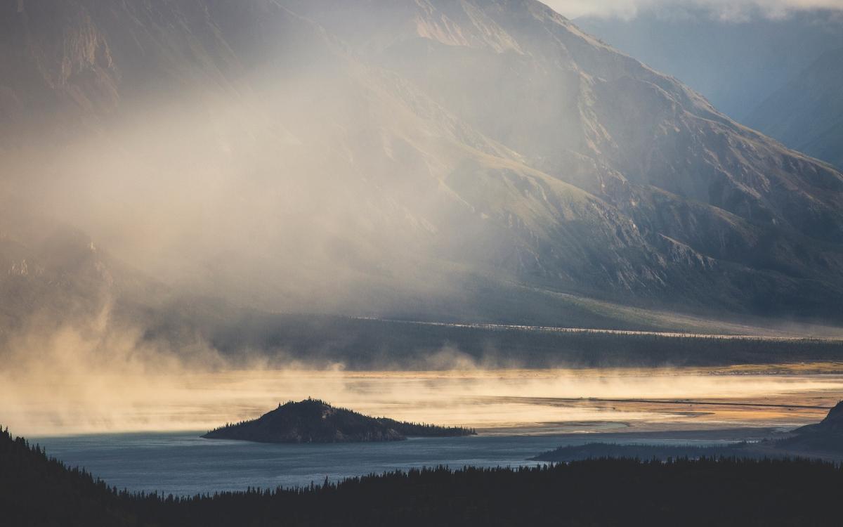
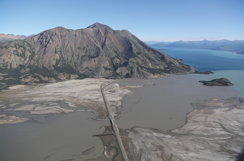
The braided channels of the Ä’äy Chù wind through the territories of the Champagne and Aishihik and Kluane First Nations, in the southwestern corner of the Yukon. The river empties into the southern end of Kluane Lake—or Lhù’ààn Mân, meaning ‘big fish lake’ in Southern Tutchone.
Something strange was happening on these lands. A bush pilot had spotted the first clue in the spring of 2016, months before Shugar’s boat got stuck. Tom Bradley had been on the return leg of his milk run, ferrying mountaineers to the foot of Mount Logan, when he noticed that the nearby Kaskawulsh River was abnormally high. He mentioned this to the owners of his flying business, Sian Williams and Lance Goodwin. Some might have given it little thought, but Williams and Goodwin also managed a research station. They immediately emailed the news to a network of scientists studying in the Kluane. As chance would have it, Shugar and a team of geomorphologists were already poised to launch a research expedition to the Yukon.
As the summer progressed, Williams and Goodwin started noticing that the Ä’äy Chù was behaving mysteriously too. The river should have been swelling with summer melt, but instead, its waters steadily dropped. Shugar arrived at the research station in August and saw the desiccated river with his own eyes.
Unprepared for an extended expedition and watching the riverbed dry in front of him, Shugar had only one option: to squeeze an entire research season into a single day.
There was no margin of error. A freak snowstorm or gale could spoil the research. There would be no room for equipment malfunction and no time to read a user manual. Even forgetting extra batteries could ruin their plans.
This hastily assembled expedition would unearth the first documented case of river piracy—when a steeply-flowing stream steals water from a gentler river. For Shugar, for those subsisting off of the Ä’äy Chù, for the local environment, nothing would ever be the same.
Dan Shugar had first visited Kluane in 2013. The landscape captivated him. He recalls sitting on a boat in Lhù’ààn Mân, gazing up the Ä’äy Chù’s valley and thinking, ‘I’ve got a whole career’s worth of research projects that I can see just from this boat.’ He was fresh into his first job as a professor at the University of Washington. Three years later, he was planning a return to the Yukon to study the annual and seasonal variation in sediment movements in the Ä’äy Chù River.
“The measurements we wanted to make weren’t particularly cutting-edge,” Shugar says. “Rather it was a river where these kinds of measurements had never been made before.”
Shugar and three colleagues—John Clague of Simon Fraser University, Jim Best of the University of Illinois and Dan Parsons of the University of Hull in the United Kingdom—had been preparing for the expedition for six months. They needed to craft research questions, apply for grants and permits, assemble equipment, coordinate logistics and reach out to the Champagne and Aishihik First Nations and the Kluane First Nation for letters of support.
As a researcher, Shugar’s interests go well beyond sediments. He’s fascinated by phenomena like floods and landslides—events that are over in seconds but can reshape landscapes for millennia. But now the script had flipped. Instead of researching disruptive geological events, some mysterious geologic event was disrupting his research by draining the Ä’äy Chù dry. The lack of water in the river made his study pointless.
So Shugar and Best backtracked along the Alaska Highway towards Haines Junction and found a wifi connection at the local bakery. They ordered drinks and opened up satellite images of the St. Elias Mountains, looking to the sky for answers. Shugar scrolled in on the Kaskawulsh Glacier, a 75-kilometre ribbon of ice winding between frost-crusted peaks. Two meltwater lakes lay at the toe of the glacier: one emptying into the Ä’äy Chù to the north, the other feeding the Kaskawulsh River to the east. Over their coffees, the two scientists examined the lakes and the glacier—looking for clues that might explain why an entire river had disappeared.
Satellites don’t really do the Wrangell – St. Elias Mountains justice. Ice, in some places as deep as a kilometre, blankets the mountains. Snow-frosted summits claw for the sky and glacial waters etch canyons into the bedrock. Glaciers flow as far as the sea, and towers of ice crash into the north Pacific.
People have lived among these mountains for countless generations, their histories shaped by the forcefulness of this environment. Twelve hundred years ago a volcano in the Wrangell Mountains erupted with 10 times the force of Mount St. Helens.
Volcanic clouds drenched the southern Yukon in ash. The catastrophe forced people southwards, some likely reaching as far as modern-day Arizona and New Mexico. (Linguistic parallels link Indigenous languages in the Yukon with that of the Navajo.)
Oral histories tell of the raw power of this land—of giant lakes and devastating floods. One such flood ripped through the Alsek valley around 1852, after the Lowell Glacier surged across the valley and bottled up the Alsek River. When the ice dam finally burst it unleashed lake waters that had backed up approximately 60 kilometres. Floodwater swept away two Tlingit camps. A century later, in 1958, a 7.8 magnitude earthquake rocked the Pacific frontier of the St. Elias Mountains. The quake unleashed a torrent of debris into Lituya Bay, Alaska, triggering the tallest tsunami ever documented—a wave that scoured mountain slopes 520 metres above sea level.
Few features in this landscape are static. Even entire drainages have reversed direction. As recently as the 18th century, Lhù’ààn Mân emptied south through the Alsek River into the North Pacific. But at that time glaciers across the Northern Hemisphere had been growing for the past several centuries. As the Kaskawulsh Glacier advanced, it severed the river connecting the Lhù’ààn Mân to the Alsek watershed. Glacial sediments gradually filled in the valley, forming a river that flowed in the opposite direction: the modern-day Ä’äy Chù.
In recent years, climate change has made the Wrangell – St. Elias range even more tumultuous. Glacial cover in the range has shrunk 20 per cent over the past 50 years. Surging rivers are executing facelifts on watersheds across the mountains. The amount of additional ice being lost each year creates roughly enough meltwater to keep Niagara Falls flowing for 70 days. In the summer of 2016 the Ä’äy Chù should have been swollen with summer meltwater, not dry.
Dan Shugar and Jim Best could only extrapolate so much from the satellite images and their seats at the bakery. “You’re seeing a bird’s eye view of something, and that’s very different from seeing something with your own eyes,” he says.
They had a hunch about why the Ä’äy Chù had vanished—river piracy. Evidence of the phenomenon exists in the geological record but had never been recorded in the modern era. Documenting river piracy in real time would be like a palaeontologist stumbling across a living, breathing, wooly mammoth.
Ten years earlier, John Clague had published a paper predicting that river piracy would someday occur between the Kaskawulsh and Ä’äy Chù River. If Shugar’s team could find their way to the Kaskawulsh Glacier they could know for sure. They needed to follow what remained of the Ä’äy Chù to its source. The key to the riddle was there, somewhere around the terminus of the Kaskawulsh Glacier, among the icebergs, and lakes of cold turquoise. Unfortunately, they had come to the Yukon expecting to collect data within shouting distance of the Alaska Highway, not deep into Canada’s highest mountain range. “I don’t think we even had proper camping gear,” Shugar says. A prolonged expedition into the mountains was out of the question.
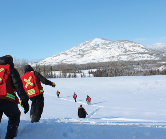
Undeterred, the geomorphologists helicoptered the 25 kilometers to the base of the Kaskawulsh and began a condensed scientific blitz. They collected fine-scale GPS readings across the valley and examined a canyon that had gnawed through the tip of the glacier. Shugar flew a drone back and forth overhead, capturing hundreds of images to merge into a 3D replication of the valley’s terrain. Their observations confirmed what they’d suspected. River piracy was happening before their very eyes.

Nine months after arriving in the Yukon, Shugar’s team published their findings in the journal Nature Geoscience. The news exploded like a viral cat video. “River piracy” was an irresistible turn of phrase—a stark example of the ongoing climate emergency. Soon Shugar was flooded with media calls. Over 150 outlets across the world reported the story, including the New York Times, the Guardian, the Washington Post and Time.
River piracy put Shugar on the map and helped propel him to a new position at the University of Calgary. But the disappearance of the river has impacted others’ lives in a much less positive way.
“It was an enjoyable paper to write and it had a good impact for me personally,” Shugar says. “But that’s a very different story for people who live off the lake.”
The Ä’äy Chù disappeared because of two straightforward realities: water flows downhill and the planet is in a climate crisis. For the last several hundred years the Kaskawulsh Glacier had acted like a dam, separating the lake that fed the Ä’äy Chù from the lake that drained into the Kaskawulsh River. But in the past 50 years, the glacier has retreated by over half a kilometre. With it, the barrier between the two watersheds has melted away. Water that should have flowed into the Ä’äy Chù now gushes through a newly formed canyon into the much steeper Kaskawulsh River.
The aftermath is stark. Today the Ä’äy Chù’s wide floodplain lies parched. Sandstorms billow out of the valley almost every summer afternoon. Lhù’ààn Mân has noticeably sunk. The island at the river’s mouth is now a hump of land in a sea of cracked mud. Forty kilometers down the lake in the small town of Destruction Bay, the marina has dried up.
In a story last summer for the Toronto Star, journalist Ainslie Cruickshank focused on how changes to Lhù’ààn Mân have impacted the Kluane First Nation. Stretches of the lake that once drew congregations of waterfowl have gone dry. Shallower water has made it harder for people to access critical fishing and hunting areas. But Cruickshank’s piece was an exception to much of the coverage, which has centered on western scientists rather than the people most impacted by the changes playing out in Kluane.
“There is a literal and a figurative lake between my community and the research centre,” Tosh Southwick of the Kluane First Nation writes in an essay for Northern Public Affairs. “Yes, the river dried up, but what does that actually mean on the ground for the people who live there? What does that mean for the families who set a fishnet in the same spot as their great grandmothers and are no longer catching any fish?”
In October 2019, the Yukon Legislative Assembly voted unanimously to declare a climate change emergency in the Yukon. Members from both sides of the aisle spoke of the loss of the Ä’äy Chù—among many other examples of how the climate crisis is impacting Indigenous communities, who are at the forefront of sounding the alarm. The Vuntut Gwitchin First Nation of Old Crow declared a climate emergency last May, and the Assembly of First Nations followed suit in July.
Meanwhile, the ramifications of river piracy are still unfolding. The Kluane River, which drains Lhù’ààn Mân, is growing shallower and shallower as the lake level drops. Lhù’ààn Mân may even sink below the level of its outflow, land-locking the lake. Chum salmon that fight upriver for 3,000 kilometers could soon find their migration route cut off. Grizzlies, eagles and a host of other species that feed off the Kluane salmon run may be forced to find food elsewhere.
Shugar predicts Lhù’ààn Mân’s outflow may once again reverse direction. The Kaskawulsh River has already pirated the headwaters of the Ä’äy Chù, and the river will gradually wash away the sediments that fill its valley. Over the coming centuries, the headwaters of the Kaskawulsh will slowly creep towards Lhù’ààn Mân, eventually creating a new outlet for the lake.
These are the sort of research questions that keep drawing Shugar back to the Yukon. In 2017, he and his team returned to the Kaskawulsh Glacier, this time to probe the layers of sediment around the glacier’s terminus for clues about its past. Piecing together the glacial history of the Wrangell – St. Elias Mountains may even help predict what the future holds.
The researchers also learned a lesson from their own past—this time they came to Kluane with food and sleeping bags. The team set up camp on a treeless island in one of the lakes at the glacier’s base. A relentless gale screamed out of the Alsek Valley, darkening the skies with grit. Each morning they woke coated with silt. They choked down meals laced with sand and drank water so murky that it resembled chocolate milk. Finally, they dug a pit, lined it with a tarp and filled it with chunks that had calved off the glacier.
“Over the course of the day the ice would melt and most of the silt would settle out to the bottom of the puddle,” Shugar says. “Then we could scoop out drinking water.”
The rivers, glaciers, and lakes of Kluane may appear very different in several centuries—a heartbeat in the scale of geological time. Then again, the changes over the past several years have been staggering. “We’re witnessing a time when glacial landscapes are changing very, very rapidly,” Shugar says. One more testament to the force of climate change.