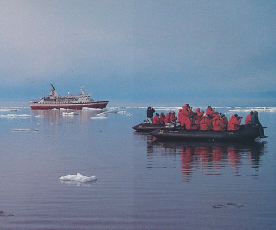
THE SAND IS FINE on Saunitalik. We have granules in our teeth after the Twin Otter kicks them up and leaves us on the island, a five-kilometre stretch in Queen Maud Gulf. Sand is in the dive gear, cameras and personal effects of the underwater archaeologists with Parks Canada. They’ve spent the last week here, diving to the wreck of HMS Erebus. Four Inuit men from Gjoa Haven, Nunavut join them to provide protection and knowledge of the island’s animals and important sites.
A few days before we arrive, the archaeologists and the men dubbed ‘guardians’ by Parks Canada walked across the island to hunt caribou. The guardians packed the animal’s meat up within its hide and hung the legs over their shoulders to carry like a backpack. A rack of ribs hangs to dry outside their wall tent. Without supplies here, the land is the only thing that will keep you alive. It’s a lesson to be gleaned from Franklin’s doomed expedition, a story that’s become legend.
Sir John Franklin left Greenhithe, England in 1845 with 128 men, destined for the Arctic. He sought a Northwest Passage and commanded the voyage from the helm of HMS Erebus. Francis Crozier captained HMS Terror. The ships overwintered at Beechey Island into 1846, and were to steer south that summer. “All well,” reads the script above a typeset note left at Victory Point on the northwest tip of King William Island in May 1847. Several versions of the form letter were left in rock cairns earlier along the expedition route to mark their progress. About a year later, in April 1848, the crew returned to the note at Victory Point, filling its margins with handwriting. They were stuck in ice, roughly five nautical miles from the cairn and had been for 19 months. They’d barely moved at all. Men had died, including their commander, Franklin. The situation was dire. The remaining 105 souls were abandoning ship to walk toward the mainland, to Back River that led to the south. Crozier was now in command. “This we know from this fantastic record in the cairn near Victory Point,” says Ryan Harris, senior underwater archaeologist with Parks Canada and lead on the Franklin shipwrecks. “Ultimately, that one note is where the historical record really came to an end.”
Between 1847 and 1859, more than 20 expeditions set out to find Franklin’s men or an explanation for their disappearance. John Rae famously returned with artefacts and stories of cannibalism; Francis Leopold McClintock came back with the Victory Point cairn note. The tantalizing clues and the lasting mystery conspired to create the Franklin mythology, giving his expedition outsized importance in Arctic exploration and making him a hero.
For nearly 170 years, even the physical locations of the ships remained a mystery. But both have been found—Erebus in 2014 and Terror in 2016—and though waterlogged and matted with kelp, the cold, dark waters of the Arctic Ocean have preserved them surprisingly well. Together with Inuit testimony collected by modern historians, the discoveries have the potential to change what we know about the expedition’s last days and what actually happened to those 129 men.

IT'S THE OPENING CEREMONY of Gjoa Haven’s inaugural Umiyaqtutt, or Shipwreck Festival. Gjoa Haven is the closest community to both Erebus and Terror and the event celebrates the expedition's connection to the local people with nights and days of storytelling, presentations about the shipwrecks, feasts, music and dancing, organized by community members and Parks Canada. Marc-Andre Bernier, head of underwater archaeology with Parks Canada, gives a rundown of what we know for sure about the Franklin expedition in a sparsely filled gymnasium. The story has been patched together from many sources. Inuit from this region have given accounts about the location of Franklin’s ships, of contact with his crew and of artefacts that could lead to their discovery. This information has narrowed down areas of interest for modern search efforts.
No one has been as diligent or dedicated to collecting and sharing these accounts as historian Louie Kamookak. “My theory is based on Inuit before the Europeans came,” he says, at his kitchen table in Gjoa Haven. There’s a massive map of the region pinned to the wall beside us. “There were four main Inuit groups around Gjoa Haven or King William Island and each of those Inuit groups had their own story of what they witnessed about those ships and Franklin’s men.”
Stories from the Nattinlingmiut of the northeast part of King William Island recall a visit with Franklin’s men at Cape Felix. The leader by then was Crozier, who they said was kind and gave gifts like a knife to cut seal meat. Each Inuit group hunted within a specific territory, Kamookak says, and when one of the ships went west toward Victoria Island, it left the Nattinlingmiut’s area. From that, Kamookak says, they drew the conclusion the ship had disappeared—it had been crushed in ice. To the south, the Ugjulingmiut had a story about Erebus drifting toward them, south past King William Island—moving in the direction the wreck was later found. Many other stories have been passed down through the generations on King William Island.
Rae’s recorded stories and McClintock’s physical evidence were starting points for future searches. But locating the ships was never as simple as following a set of clues—not for modern search teams or historians like Kamookak. Nineteenth century expeditions and Inuit described locations, distances and events differently, based on their own cultural context. One search party led by Frederick Schwatka relied heavily on Inuit knowledge and he interviewed people who had met members of the expedition. “We can read in Schwatka, in translation from German, one of the wrecks was ‘gesunken off Grant Point, six miles to the west,’” says Harris. “Well, the Inuit didn’t say ‘Grant Point,’ ‘west’ or ‘six miles’ either. This is all filtered and reinterpreted by searchers.”

Kamookak has spent more than 30 years recording oral history of the Franklin expedition. He pieces together traditional place-names from Inuit accounts (like Qabluunaqhiurvik, “place to meet white men”) and learns about families who were in contact with the searchers. Who exactly did Schwatka speak to? Who did McClintock meet with and how does that bear on the information they gathered? “It’s almost every few months I get a new theory or understanding of what’s happened,” Kamookak says.
He still wonders how Terror ended up in Terror Bay. (The name, by the way, was given to honour the ship when it was still lost, not because it was thought to be there on the southwest edge of King William Island.) The Victory Point cairn note tells of the plan to leave the following day on foot to Back River, which opens on the coast of the mainland just south of King William Island. But Kamookak doesn’t believe they ever made it there. “It doesn’t make sense that they were really going to Back River,” he says. An expedition from 1839 mapped the Arctic Coast and proved there was a water passage to the south of King William Island, but little was known about what lay to the east. (The prevailing theory had it connected by land to Boothia Peninsula.) Kamookak reckons that when they trekked east across “King William Land” they discovered it was in fact an island. The men returned to the ships to set sail once ice conditions permitted, travelling around the top of the island and down the east coast—the same largely ice-free route used by Roald Amundsen nearly 50 years later on the first successful voyage through the Northwest Passage. When they reached Terror Bay, it would have been too late in the season to continue on. By this point, Kamookak says, it was probably 1850 and most of the men were dead or dying.

“THE LOCATION OF THE SHIPWRECKS themselves changed the story completely. The story was always: the ships were abandoned northwest of King William Island and then the men travelled south by foot and died of starvation or scurvy. Now, we know that potentially these vessels were re-manned and brought down south,” says Charles Dagneau. He is standing in front of a 3-D image of the wreck of the Erebus. The actual wreck is about five kilometres away from our camp at Saunitalik. The ship sits aground just offshore an even smaller island.
Bernier says, both ships likely sailed through Alexandra Strait, between the western tip of King William Island and the cluster of Royal Geographical Society Islands, when it was previously believed only one had. “That’s basically also on the trail of the expedition that we thought was the land retreat of the men,” he says. That means those graves and artefacts found on King William Island might need to be reinterpreted. Were they visited after the ships were abandoned and the men were on foot? Or after the ships were re-manned and sailed south?
The shipwreck locations seem to validate the theory that Franklin, known in his day as an inflexible captain, was single-minded in following the orders he was given. “They were meant to explore to the northwest to see if there was this almost fabled Polar Sea, which there wasn’t. Failing that, [they were] to proceed southeast to the mainland to link up with shoreline explorations done by Franklin himself during his first and second overland expeditions,” says Harris. “He was following his orders, really, to the letter. Unfortunately, that directive from the admiralty led those men to one of the worst ice-choke points in the central Arctic.”
Inuit oral history tells that the ice never thawed during the time Franklin’s men were there and breathing holes never opened for seals. It was so bad, the Ugjulingmiut of King William Island were forced to migrate south for fear of starvation. “That tells you that Franklin’s men, the time they were there was also a bad time for the Ugjulingmiut,” says Kamookak. “So there was a lack of stories and not much help for the qabluunak that were in trouble.”

The gaps in the story—of Inuit accounts and evidence left from the crew—may be filled through examination of the ships themselves. Starting in 2008, the Erebus and Terror search-team spent 12- to 13-hour days in the summer, looking at swath after swath of detailed sonar images for any remnant of a ship on the seafloor. They would cover roughly 1,500 square kilometres.
Erebus was found first, in September 2014, in Wilmot and Crampton Bay. The area was relatively unaffected by ice keels that scour the seafloor in other parts of the Arctic and could have destroyed the wreck. Terror was also found shockingly intact. Glass window panes in the stern are undamaged, part of the mast still stands and the decks are completely sealed. “It’s almost a fairy tale shipwreck,” says Harris.
Marine archaeologists have logged more than 250 hours of diving to explore Erebus since it was found. The day before we arrive at Saunitalik, the team was up at 4:30 a.m., when the late-August weather was calm, to check on the condition of the wreck. They took photos and video of Erebus, ten-metres underwater.
Later, in the equipment tent, marine archaeologist Thierry Boyer shows off his underwater camera, with its long arms and metal elbows that let the lights at each end manoeuvre into cramped spaces, like under a collapsed deck. He’s documented every piece of the wreck the team can access—every square centimetre has been mapped out on a 3-D grid. Erebus has been checked for stability and its vulnerability to barnacles, mussels and other flora has been assessed. This makes up the bulk of the work done at the wreck so far. Next summer, they will focus on one of the largest excavation projects ever undertaken in Canada.
A refitted coast guard ship will be dedicated to these efforts. The RV David Thompson sleeps 14 and will offer more protection, amenities and comfort than the three dome tents and two wall tents that comprise the Saunitalik camp. The ship will tow a specially designed barge with a decompression chamber so divers that suffer from the bends can get treatment immediately. And there is a shipping container-cum-laboratory to let them properly handle artefacts. Everything that is brought up from the wrecks has to be stabilized, packed wet and sent to labs down south to be conserved. After 170 years submerged in saltwater, these pieces can rapidly crumble, warp and crack if they aren’t cared for properly. Every item will be photographed and tagged with coordinates of where it was found. “Context is the most important thing,” says Marc-Andre Bernier. Some artefacts can be identified on site, but others require outside examination from experts.
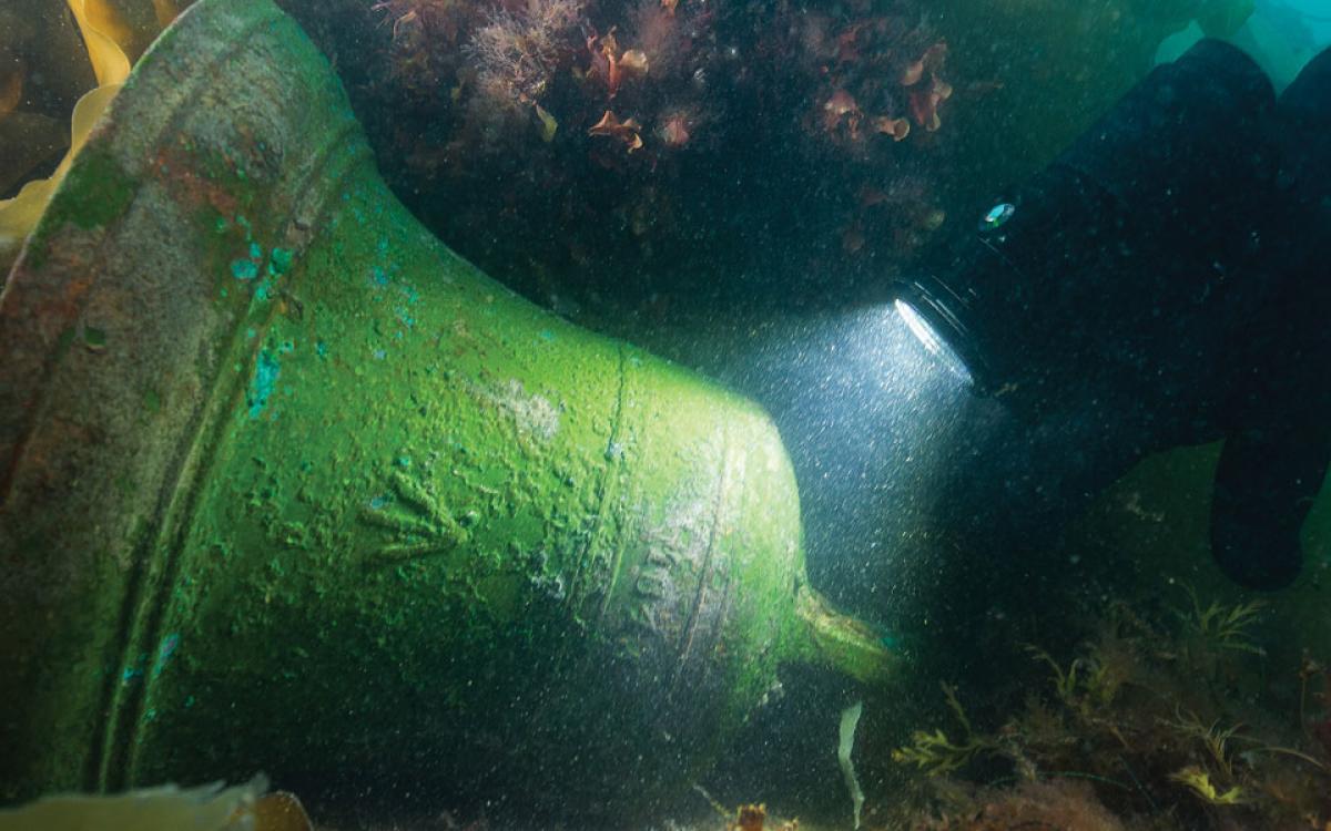
Crews have pulled 65 artefacts from the wreck of Erebus. They excavated the brass bell that would have tolled every half-hour to mark the passage of time aboard the ship. They have found dishes, cutlery, navigational instruments and a tailored leather boot with a trace of sealskin that was probably used for lining or decoration. “That type of personal artefact really brings the archaeology to another level—a human level,” says Dagneau. “What’s great is the science is so developed now, we’re able to take samples from the sole of the boot. There were some tiny fragments of skin remaining and that was enough to allow DNA reconstruction.”
The Government of Nunavut already has a database of 19 crewmembers whose DNA profiles have been constructed from their living descendants. The owner of the boot wasn’t one of the known profiles, but there are other ways of figuring out who is tied to each item: the location of the artefact on the boat, what that artefact was used for, or any sort of adornments it had can tell a story. A cross belt plate—the brass centre of the white straps that cross a soldier’s chest—is believed to have belonged to Daniel Bryant, Royal Marines sergeant on board Erebus. “We happen to have also found uniform buttons next to that plate, so we have groups of finds in that shipwreck that relate to certain individuals.”
Hovering over the wreck as they dive, the different spaces of the ship are visible, offering a glimpse of what it was like to live on board in the mid-19th century. They tell how the owner of the boot or Daniel Bryant or Sir John Franklin might have spent his last days. There’s a galley stove where the cook would have prepared food. There are seamen’s chests—benches divided in two that serve as storage and seats for two men each. There is clear distinction between the officers’ cabins in the back and the seaman and marine’s quarters in the forecastle. “In all of these specific areas you have in your mind what happened,” says Dagneau. “Our job as marine archaeologists is to reconstruct what happened with the overall expedition, yes, but also to understand the day-to-day lives of the people on board.”
And crews still cling to the hope they’ll find a Holy Grail like a logbook that continues the story from what’s written on the Victory Point cairn note. There’s a good chance of finding more personal items, like a portrait of Lady Jane Franklin, from her husband’s cabin. And there are still plenty of questions to be answered. Where is Franklin? The first few men who died on the expedition were buried on land. Was he too?

The Nattinlingmiut who met Crozier also shared a story of Franklin’s burial. They believed that after the leader was laid on the ground, his body turned to stone because he was a shaman. Inuit would wrap a body in skins and leave it at the ground’s surface when a person died. “They weren’t right at the burial ceremony but once [the crew] left they went to see it and all they could see was stone,” explains Kamookak. His own great-grandmother told a story of coming across unfamiliar artefacts as a child, near the northwest shore of King William Island. Among them was a pile of stones, the length of a person, with a rock at the end that had strange markings on it. Kamookak has led four ATV excursions through the area in search of this place his great-grandmother described. So far, to no avail.
This isn’t just the story of British sailors and an ill-fated expedition. It’s part of a larger story about the history of the Arctic and its people. Royal Navy wrecks on Arctic shores have affected trade relationships, migration and the wellbeing of Inuit and Dene. McGill anthropologist James Savelle suggested the Netsilik Inuit who now live predominately in Gjoa Haven and Kugaaruk—originally from Boothia Peninsula—may have extended their territory to the southwest to take advantage of the artefacts on board the Franklin wrecks. Their migration gradually displaced the Ugjulingmiut of that area. Inuit boarded the ships after they were abandoned, salvaged useful materials and cached other items to return to later. In the National Maritime Museum in Greenwich, England, there’s a knife an Inuk cut from the sword of a crewmember on board Erebus—the blade bears the broad-arrow mark of the Royal Navy.
The story of the Franklin expedition is written in these ships and in the minds of the people who know this place best. The bell of Erebus was raised in 2014, corroded and covered in a greenish patina. The broad-arrow mark is etched into the bell’s curve, along with the year 1845—the beginning of Erebus’s final voyage. “It would have announced the change of the watches several times a day,” says Ryan Harris. “Did they maintain that discipline to the end? Or at some point, did they no longer have enough manpower to have different watches at night and throughout the day? When did the simple passage of time lose all meaning to these people when there was no longer the hope of ever going home again?”
Editor's note: on April 26, 2018 the Government of Canada announced a formal agreement was signed with Britain conirming the two ships and artefacts found inside would be the property of Canada and the Inuit Heritage Fund. The already located 65 artefacts will be the property of Britain.