Real-world Learning
Yukon University’s environmental monitoring program is a study in traditional knowledge and western science
By Rhiannon Russell
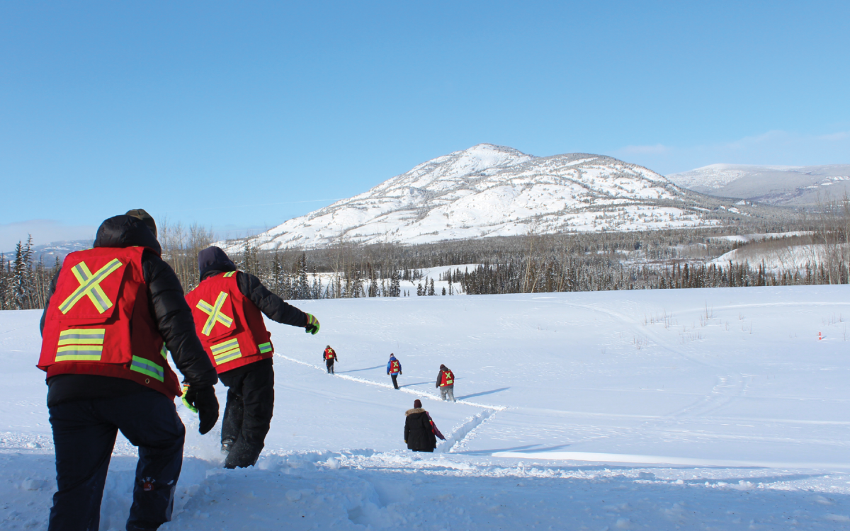
The students stand in an open space sandwiched between the Takhini River and the Alaska Highway. Underfoot, below 80 centimetres of snow, lies an old section of the road. Recently, the highway was relocated due to what’s known locally as “the slump.” An area of ice-rich permafrost has thawed, causing the ground to cave in and slide into the river. The road was at risk of getting swallowed by the slump, so the Yukon government began moving it in 2023.
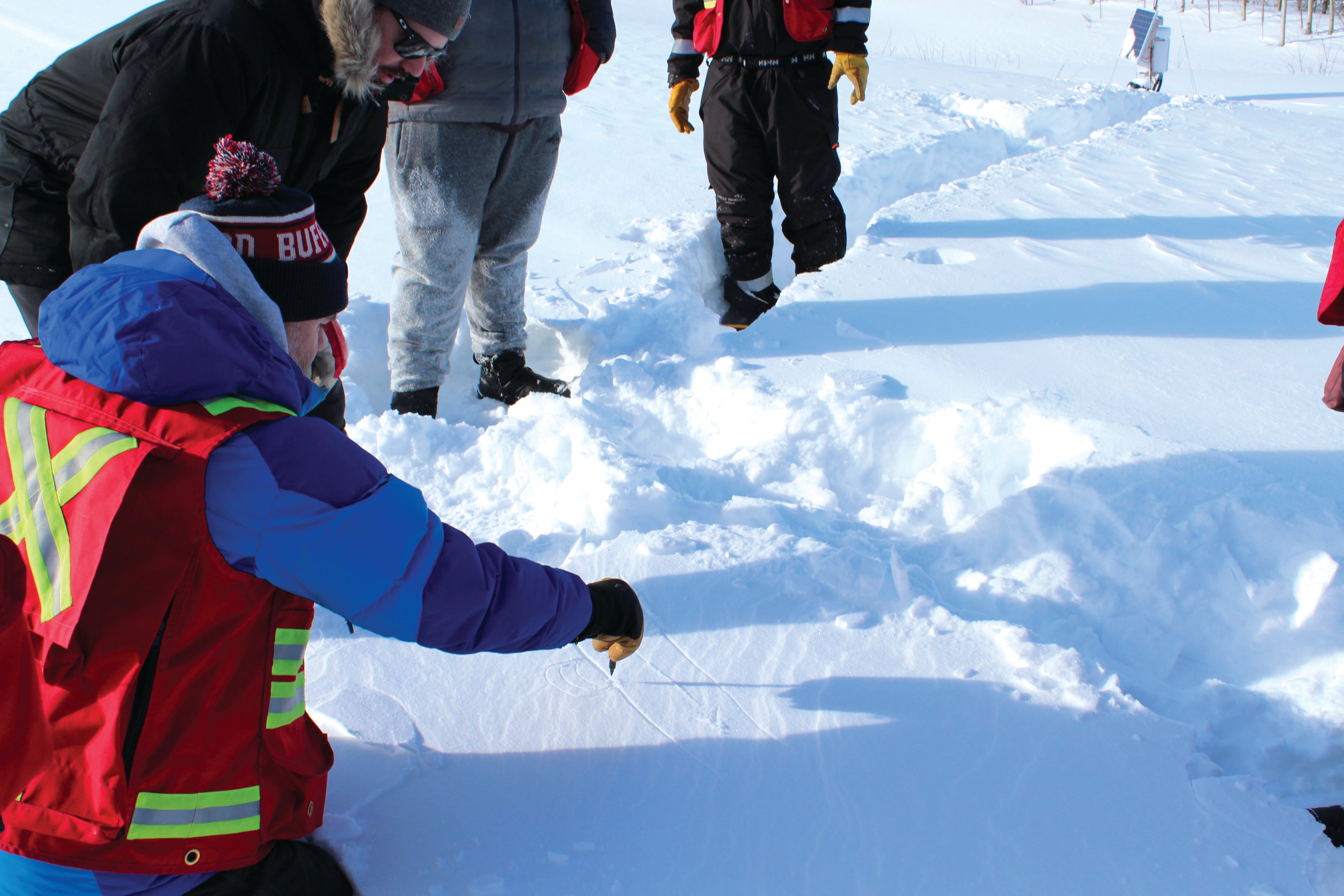
Retrogressive thaw slumps (that’s the technical name) are rarely so accessible, and this one’s proximity to Whitehorse—just 30 kilometres away—makes for a great permafrost lesson. That’s why the students are here. The seven adults in Yukon University’s environmental monitoring certificate program, which is open only to northern First Nations students, are completing fieldwork training that will prepare them to work for mining companies, governments and consultants. Lessons cover data collection, aquatic and terrestrial monitoring, remediation at contaminated sites, erosion, GPS use and navigation and climate and weather.
Students learn hands-on skills and graduate ready for the industry, where there’s big demand for people with this training. The program also incorporates western science and traditional knowledge. “Whether you’re out there with a bunch of western sensors or you’re out there on your trapline with your First Nations family, if things on the land matter to you, then you want to protect them,” says lead instructor Scott Keesey. “And you’re in a better position to protect them if you can make informed decisions, and informed decisions come from information.”
Before heading out to the slump, students sit in a basement boardroom at the university’s Whitehorse campus for a crash course with permafrost researcher Louis-Philippe Roy. They jot down notes in yellow Rite in the Rain notebooks as Roy poses questions about their existing knowledge of permafrost. Some of the students already have experience working for their First Nations.
“What influences permafrost distribution?” reads one slide. The students pipe up with their responses, and as Roy clicks on his laptop, each answer appears on the screen: latitude, elevation, surficial geology, aspect and ground cover. Tussock grasses are an indication of permafrost, says Roy, though they’re “a bitch to walk through.” The class laughs and then a student from Ross River Dena Council chimes in: “Especially if you’re carrying a caribou.”
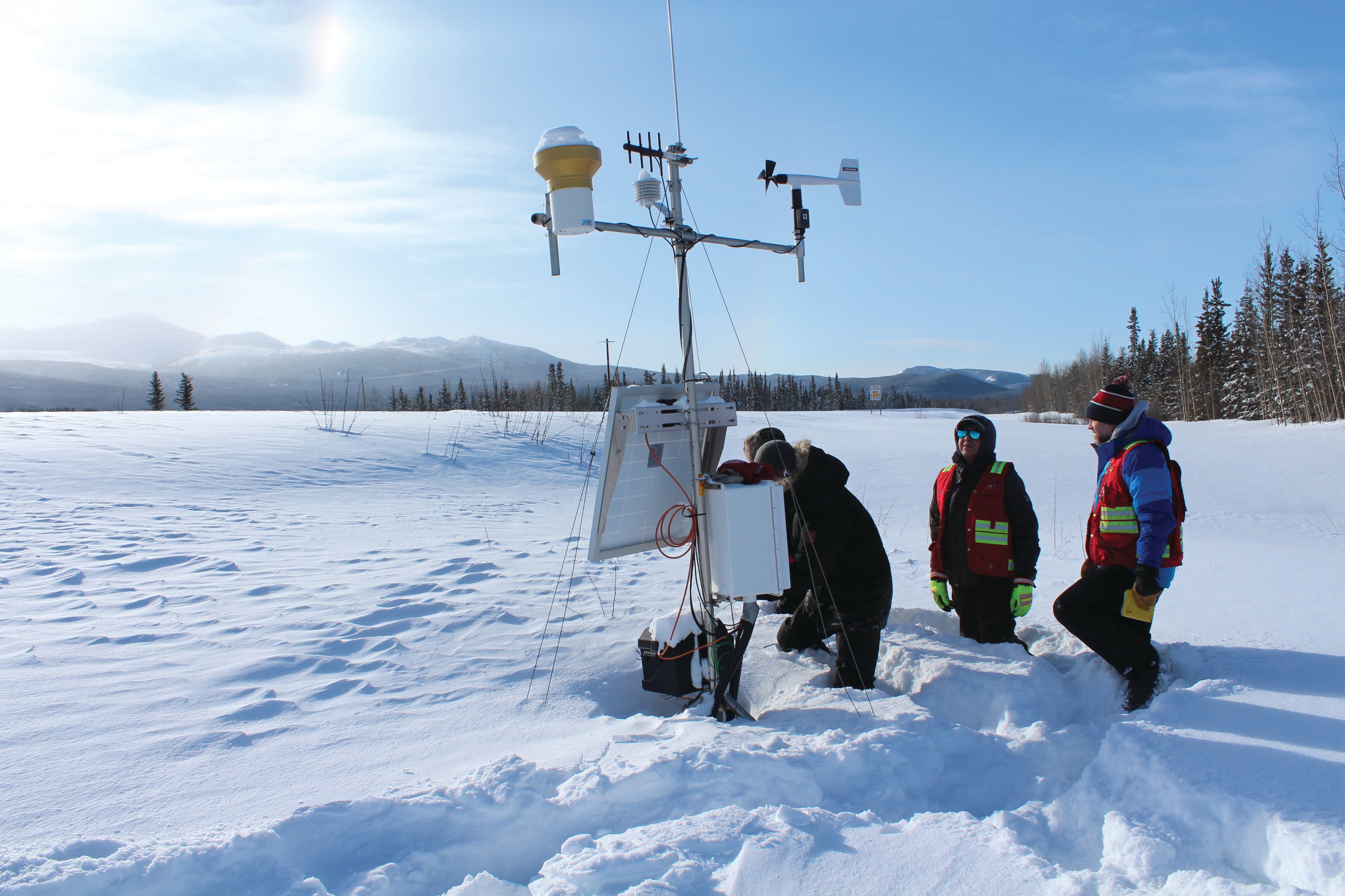
When it’s time to see an example of permafrost thaw, a small, white bus transports the group to the slump. Wearing red safety vests, the students traipse single file down a snowy slope to the old section of highway, where a weather station with a solar panel collects data. Some of them are at different stages in the program, because the 10 week-long modules, which roll out over 18 months, don’t have to be taken in sequence. Students can work full-time while they study.
Darren Bullen is finishing his ninth module. As a land and resources officer for his First Nation, the Tr’ondëk Hwëch’in, he inspects mines, rivers and creeks, patrols the Dempster Highway for poachers and deals with firewood permits. “We watch everything,” he says. Bullen has had the job for 15 years, but he sees the program as a way to learn about new techniques and tools. He also runs a business doing geographic information system mapping and data collection using drones, and he thinks what he learns will help him with that, too.
The program isn’t Whitehorse-centric. One of Bullen’s favourite modules was the week he spent in Atlin, B.C., learning about water monitoring at an old mining area that’s now in reclamation. Students studied fish habitat and watched a grayling run. This year, students will visit the Minto and Keno Hill mines and the Snowline Gold and Casino exploration projects.
On the side of the Alaska Highway, the bright sun makes 20 below feel almost balmy. Standing near the massive slump, the students question Roy: Could highway vibrations have contributed? (Good thinking, but not likely.) Could vegetation be added to stabilize it? (Right instinct, though this thaw is too big and happened too fast.) What about planting poplar trees along the highway? (Their roots aren’t deep enough.) They talk about how permafrost has affected their home communities, from Dawson City’s unstable recreation centre to Ross River’s crumbling school. The subtext seems clear: Having observed the environmental changes happening around them, these students already have experience that’s relevant to the field of monitoring.
As the group prepares to trudge back up the hill to the bus, everyone’s eyes turn to the mountains across the highway. Two patches of light—sun dogs—flank the sun. A halo overtop is mirrored by a small, upside-down rainbow. Exclamations of “Whoa!” and “Wow!” ripple through the group.
“That’s a circumzenithal arc,” Keesey says, referring to the flipped rainbow. “This is right out of a sun dog textbook. Each one of these features is the sun shining through a different ice crystal.” A permafrost lesson with a side of sky study—all environmental monitoring.
Arviat Hits the Books
Inuit Nunangat University chooses the west coast of hudson bay for main campus
By Arty Sarkisian
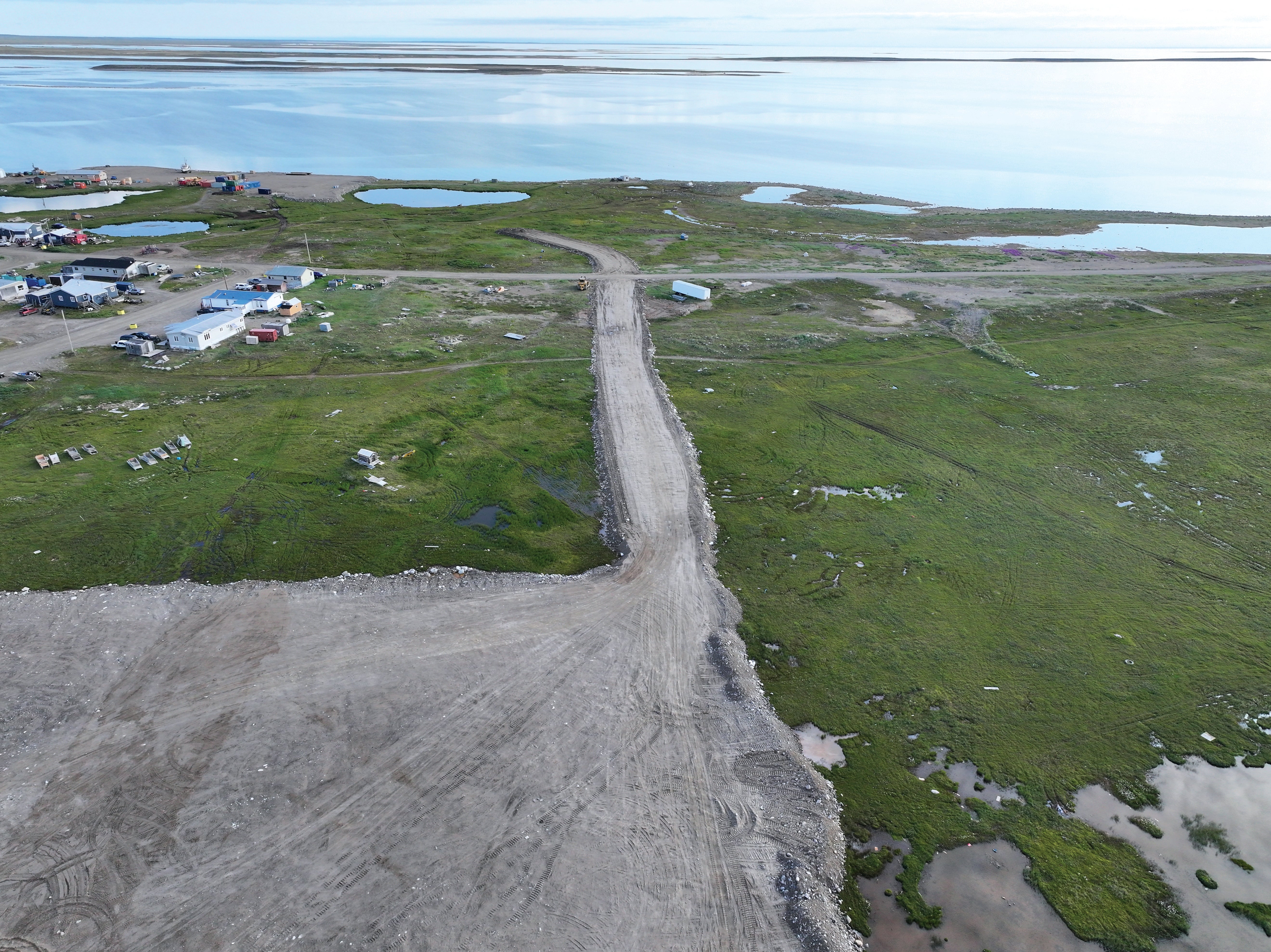
Universities learn from the communities that host them. And Arviat’s mayor Joe Savikataaq Jr. says his hamlet will be a good teacher to Canada’s first Inuit-led university. “I’m in the middle of nowhere in a tent,” he says after a day of snowmobiling in the tundra as part of a hunting trip for Arctic wolves with his father and uncle. With eight more hunting days to go, he’s camping near the NWT-Nunavut border. “I think this is why we will be good hosts for the university—traditions like this are still alive.”
Just a few weeks earlier, his small community on the western shore of Hudson Bay had won the competition to host the main campus of a $200-million university under development by Inuit Tapiriit Kanatami (ITK), a national organization representing the country’s Inuit. With an estimated 100 students and 80 staff members, the school will be the first Inuit-led institution to provide undergraduate and graduate degrees in the Canadian Arctic. Despite its thriving wolf-hunting heritage, though, Arviat was not an obvious winner.
The idea for Inuit Nunangat University has been around for more than two decades and was part of ITK’s national strategy for Inuit education introduced by now-Governor General Mary Simon, who was then the organization’s president, in 2011. After multiple resolutions, requests for proposals and private and federal funding announcements, the university finally asked interested Inuit communities to pitch themselves as hosts of the main campus.
Many places sold themselves as the smart capital of the North, but only seven communities made the 2025 shortlist: Arviat, Cambridge Bay, Inuvik, Iqaluit, Kuujjuaq, Nain, Puvirnituq and Rankin Inlet. While Savikataaq’s community gets the main campus, three others will host regional hubs.
Arviat overcame several shortcomings in pursuit of its goal. One of the smallest communities on the list, it’s experiencing a stubborn tuberculosis outbreak and has major infrastructure concerns, including one of the oldest power plants in the territory. Worse, in 2024, Nunavut’s public housing agency classified the town’s public housing need as “critical.” And Sakku Investments Corp.’s soon-to-be-completed modular-homes factory, which will require 40 full-time employees, could bring in more house hunters.
But Savikataaq says the landfill, sewage and water systems can accommodate an influx of new people. And while the factory may increase the need for housing, it’s scheduled to start manufacturing 40 houses a year in 2026, which will help solve the problem.
Arviat’s biggest advantage was a willingness to provide land for the future university. Before submitting its bid, hamlet council set aside 10,000 square metres of the community’s waterfront on the east end of town. Another plus was the prevalence of Inuktut as the first language. According to the 2016 census, 94 per cent of the hamlet’s Inuit population spoke Inuktut as their mother tongue, one of the highest levels in the territory. That will come in handy as the eventual hope is for all students and professors to speak only Inuktut in the classrooms.
Aside from the preservation of Inuit culture and language, the school’s goal is to give future students a real-world university experience, including credits and degrees that will be accepted nationally and internationally. In a perfect world, all the graduates will find jobs in the Arctic, says Riley Winters, lead of ITK’s Inuit Nunangat University team, but they should have the flexibility to use their degrees no matter where they go in life.
The current academic plan includes six faculties with five to 11 major and minor programs, including law, medicine and art history. Things are still a “work in progress,” Winter says. “But we do know where we’re going to start.”
After the university is built in 2030, it will launch the first two programs: a bachelor’s in education and a master’s in Inuit sovereignty and Inuit self-determination. Other programs will follow once the university hires professors and develops the syllabi.
Faculty recruitment is set to start in 2027, but Inuit “knowledge holders” often don’t have the PhDs that most southern universities require. To ensure the school hires locals, Winters says, “There has been some conversation around maybe granting honorary degrees or something.” Savikataaq, a college-educated heavy-duty technician, says he could see himself as a future university instructor: “Anything is possible.”
For now, though, the mayor is more worried about crushing gravel. A lot of it. Approximately 18,000 truckloads kind of a lot. That’s how much will be needed to prepare the 10,000-square-metre area for construction, which is the hamlet’s responsibility. Arviat is also getting ready to cut up some caribou and seals for a community feast planned for April 23 at the community hall to celebrate the victory. “At this point, we don’t even understand all the benefits the university will bring,” Savikataaq says. “And we are ready to make it happen.”
Bacon, Eggs & Moose Lasagna
How a Łutsël K’é school is fighting food insecurity—and teaching kitchen skills
By Rhiannon Russell
On Pasta Day at Łutsël K’é Dene School last fall, about 100 people wandered through the doors, welcomed by the aromas of cheese, meat and garlic. The hearty lunch cooked up by students and staff included spaghetti, with a choice of moose or ground beef sauce, ground moose lasagna and mac and cheese, along with Caesar salad, garlic toast and fresh veggies. Family members, RCMP officers and Łutsël K’é Dene First Nation employees, as well as the chief, sat together with their loaded plates at tables in the school’s kitchen, gathering space and library. Every month or so, the K-12 school opens its doors for a community lunch, with students in the cooking class helping prepare the meal. Principal Karen Gormley watched the conversations, smiles and laughter around her and decided it was “one of the greatest things this year.”
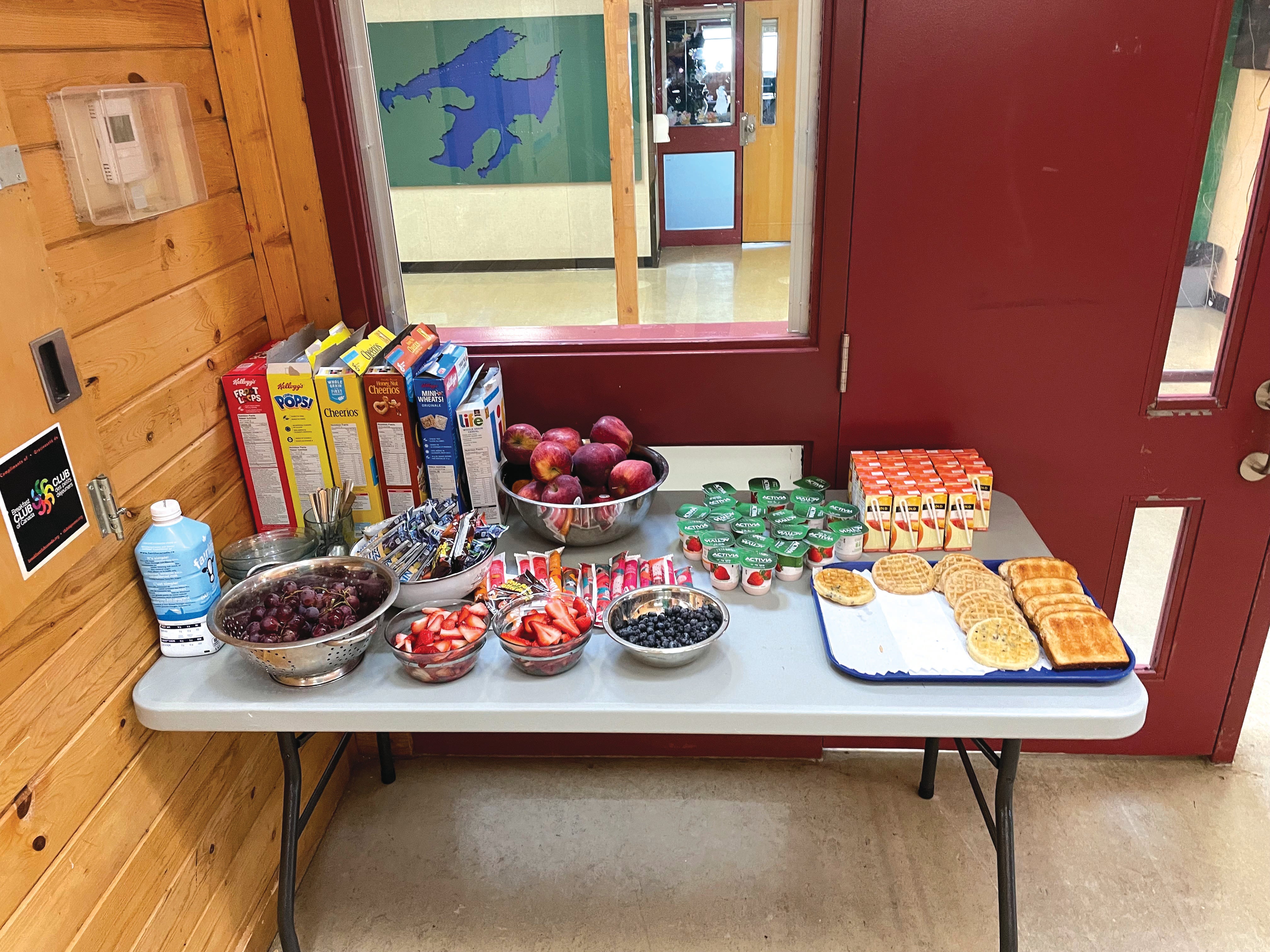
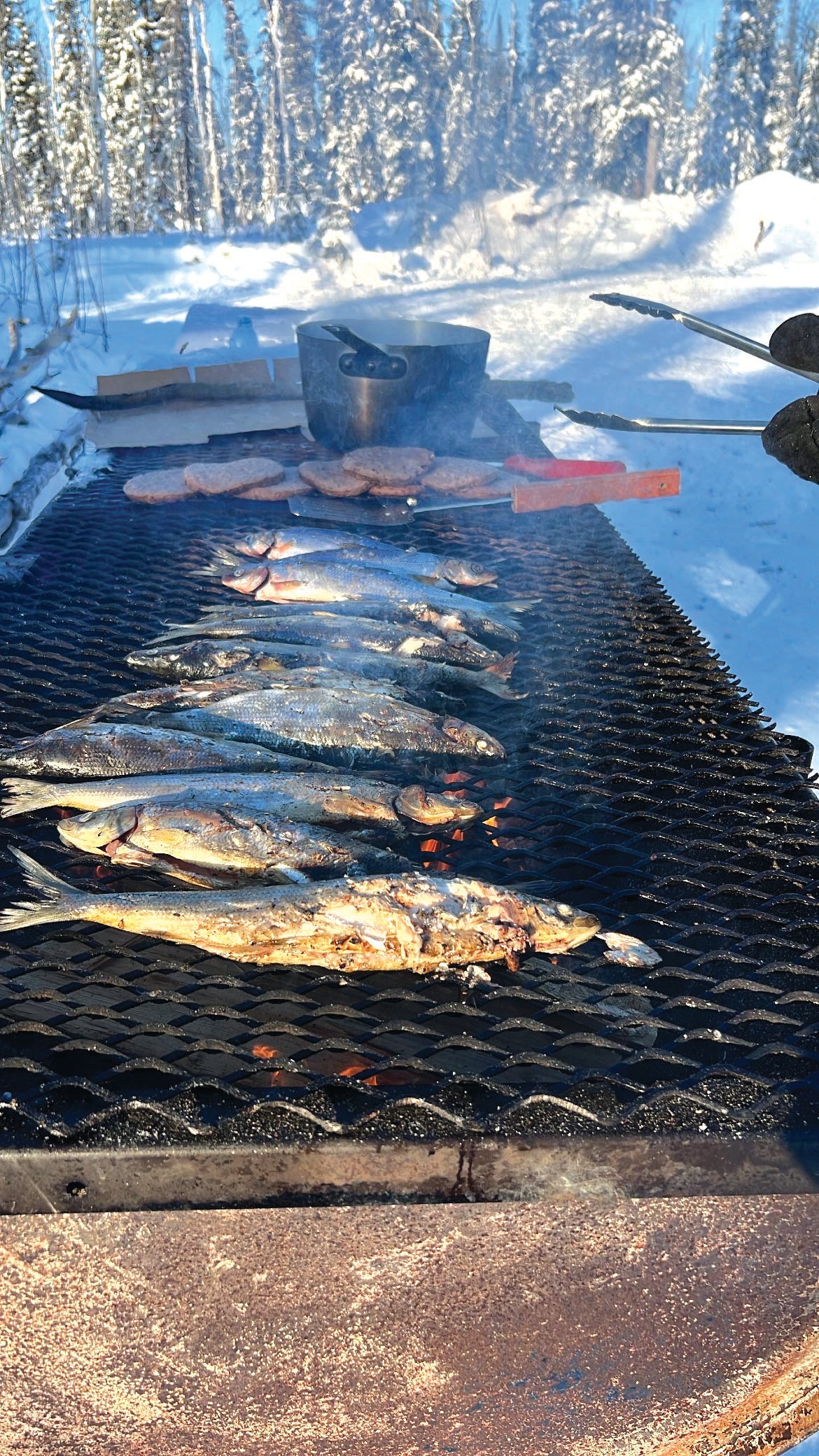
The community lunch is part of the school’s meal program. Every day, students have a hot breakfast that ranges from bacon and eggs to sausage and pancakes, plus smoothies and fruit. Sometimes, traditional foods are available. “At first, we were a little reluctant to do that in the mornings,” says Gormley. But fish and caribou are popular. Kids also get snacks in the morning and afternoon. The consistent supply is possible because of a blend of funding the school gets from the federal and territorial governments and the Colin B Glassco Charitable Foundation for Children, which offers financial support to kids’ causes.
School meal programs aren’t new in Canada, where one in four children lives in a food-insecure household, but they’re often at the mercy of fluctuating, inconsistent funding. In 2024, the federal government announced the $1-billion, five-year National School Food Program, intended to offer meals to 400,000 children across the country. Last fall, Prime Minister Mark Carney committed to making the food program permanent.
The support is great news, says Dane Mason, chair of the board at the Food First Foundation. Founded in 2008, the NWT charity has offered school meal programs and nutrition education through a mix of funding sources including, most recently, the territorial government and private donors. Mason has seen the benefits during his decade of involvement: increased attendance, improved focus, higher graduation rates, more energy. Learning on an empty stomach is difficult. Data from the
Toronto District School Board showed that students who regularly ate breakfast were 17 percentage points more likely to be on track to graduate compared to students who didn’t.
The new federal money goes to schools directly through the NWT government, meaning Food First doesn’t have as great a role as it did—at least not until schools identify gaps in the national funding requirements the charity could help fill. “It’s the biggest change we’ve ever had,” Mason says. “We’re looking at how we’re going to adapt to the new funding environment but also celebrating that there’s permanent funding for the very thing that we tried to get going for a decade or more.”
Food insecurity especially affects the North because of its remoteness and high cost of living. In Łutsël K’é, a fly-in community, staple items are subsidized through the Nutrition North Canada program. But flight delays or disruptions can lead to shortages of eggs, milk, fruits and vegetables. That’s partly why the school grows vegetables in AeroGardens, small indoor hydroponic systems. “We’re always looking for ways that we can improve food security,” Gormley says, “not just within our school but within the whole community.”
The breakfast program plays a big role in this effort. Every morning, students and teachers gather in the kitchen to eat. For students, it starts the day off right, and it’s a way for teachers to check in with kids outside the classroom. Who’s tired and may need a nap later? Who has extra energy and might benefit from running around the gym for a bit? “As you’re having these conversations,” Gormley says, “a lot of times, it leads to other conversations that are more meaningful.”
Morning and afternoon snacks include fruits and vegetables, cheese and crackers and yogurt parfaits. While students wanted chocolate-covered granola bars, Fruit Roll-Ups and other sugary items, Gormley was determined to focus on healthy options. So, she’s compromised, bringing in sugar-free fruit leather and hearty granola bars.
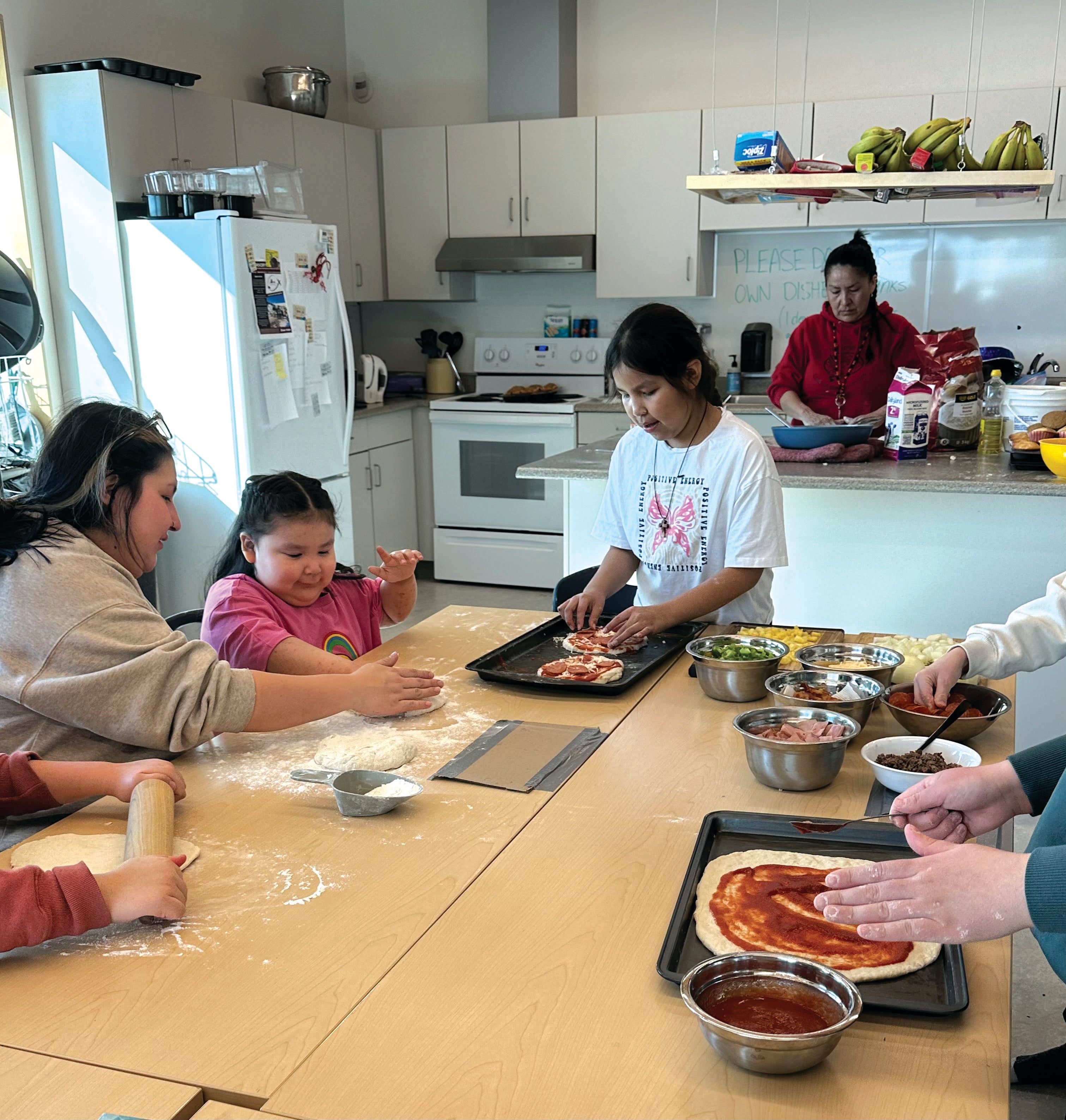
On a recent Saturday, the school’s kitchen was bustling as 15 students made dough, grated cheese and topped pizzas with green peppers, mushrooms and pepperoni. Ten adults pitched in, too: Gormley, a few teachers, the school’s breakfast cook (along with her niece and nephew), an RCMP officer, a nurse and two employees from the recreation department. This program, called Kids in the Kitchen, isn’t for school credit; it’s volunteer. Funded by the territorial government, it helps children develop cooking skills—and they get to eat what they make.
The “pizza extravaganza” was a learning experience for the students and the adults. “How do we know if we need to add yeast? And what happens when your principal forgets that the yeast has been sitting for far too long?” Gormley laughs. “Just being together and working together was great.”